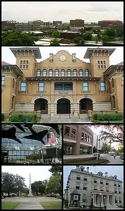
彭萨科拉 (佛罗里达州)
彭萨科拉(英語:)是美国佛罗里达州埃斯坎比亚县首府。根据2006年的人口普查,彭萨科拉市区人口为53,248人。美國海軍在該市設有海軍航空基地。
| 彭萨科拉 | ||
|---|---|---|
| 城市 | ||
| 彭萨科拉市 | ||
 | ||
| ||
| 綽號:America's First Settlement, The Upside of Florida, P-Cola, The City of Five Flags, Oldest City, Red Snapper Capital of the World,[1] World's Whitest Beaches,[2] Cradle of Naval Aviation,[3] Western Gate to the Sunshine State[4] | ||
 Location in Escambia County and the state of Florida | ||
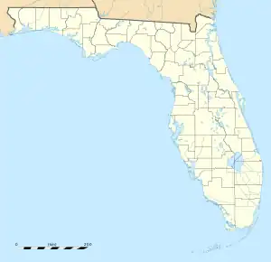 Pensacola 於佛罗里达州的位置  Pensacola 於美國的位置 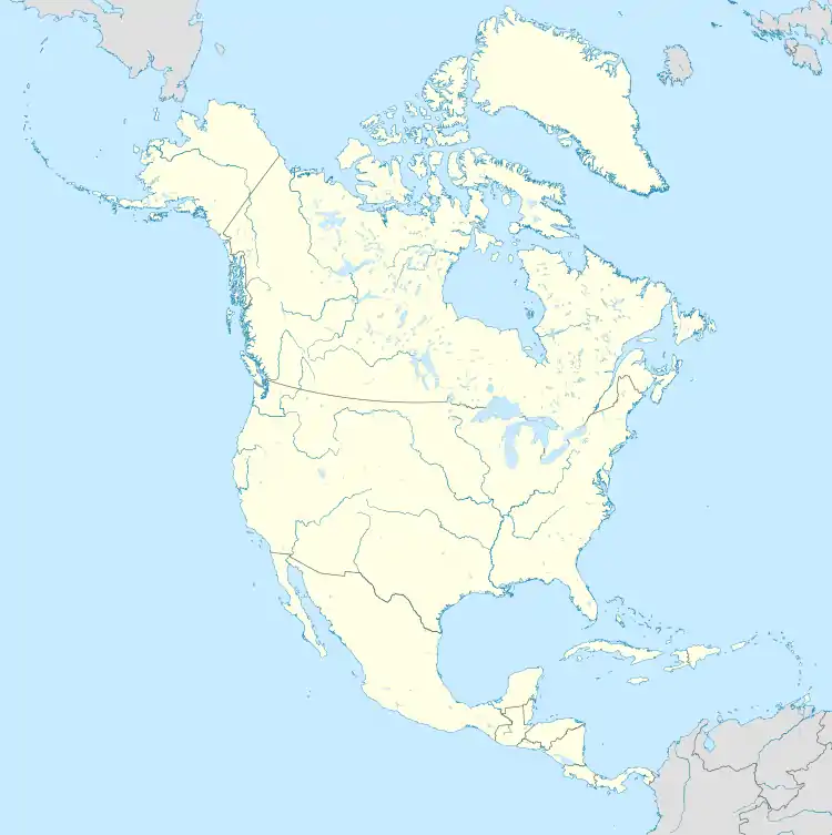 Pensacola Pensacola (北美洲) | ||
| 坐标:30°26′N 87°12′W | ||
| 國家 | ||
| 州 | ||
| 县 | 艾斯康比亞縣 | |
| First settled | 1559 | |
| Resettled | 1667 | |
| Incorporated | 1821 | |
| 政府 | ||
| • 类型 | 市长-议会制政府 | |
| • 行政机构 | 彭薩科拉市議會 | |
| • 市長 | Grover C. Robinson IV | |
| • Council President | Andy Terhaar | |
| • Council Vice President | P.C. Wu | |
| 面积[5] | ||
| • 城市 | 41.00 平方英里(106.18 平方公里) | |
| • 陸地 | 22.64 平方英里(58.63 平方公里) | |
| • 水域 | 18.36 平方英里(47.55 平方公里) | |
| • 都會區 | 1,669.30 平方英里(4,000 平方公里) | |
| 海拔 | 102 英尺(31 公尺) | |
| 人口(2010) | ||
| • 城市 | 51,923人 | |
| • 估计(2019) | 52,975 | |
| • 密度 | 2,340.09人/平方英里(903.52人/平方公里) | |
| • 都會區 | 497,883 | |
| • 都會區密度 | 1,669.30人/平方英里(644.52人/平方公里) | |
| • Demonym | Pensacolian | |
| 时区 | CST(UTC−6) | |
| • 夏时制 | CDT(UTC−5) | |
| ZIP code | 32501, 32512, 32534, 32591, 32502, 32513, 32559, 32592, 32503, 32514, 32573, 32593, 32504, 32516, 32574, 32594, 32505, 32520, 32575, 32595, 32506, 32521, 32576, 32596, 32507, 32522, 32581, 32597, 32508, 32523, 32582, 32598, 32509, 32524, 32589, 32511, 32526, 32590 | |
| 電話區號 | 850/448 | |
| FIPS code | 12-55925[6] | |
| GNIS feature ID | 0294117[7] | |
| 網站 | www | |

地理
| 佛罗里达州彭萨科拉国际机场(1991−2020年正常值,1879年至今极端数据) | |||||||||||||
|---|---|---|---|---|---|---|---|---|---|---|---|---|---|
| 月份 | 1月 | 2月 | 3月 | 4月 | 5月 | 6月 | 7月 | 8月 | 9月 | 10月 | 11月 | 12月 | 全年 |
| 历史最高温 °C(°F) | 27 (81) |
28 (82) |
32 (90) |
36 (96) |
39 (102) |
39 (102) |
41 (106) |
40 (104) |
39 (102) |
36 (97) |
32 (89) |
27 (81) |
41 (106) |
| 平均最高温 °C(°F) | 23.8 (74.9) |
25.2 (77.4) |
28.1 (82.5) |
29.6 (85.2) |
33.7 (92.6) |
35.4 (95.7) |
36.1 (97.0) |
35.7 (96.2) |
34.9 (94.8) |
31.6 (88.9) |
27.9 (82.3) |
25.3 (77.6) |
36.9 (98.4) |
| 平均高温 °C(°F) | 17.1 (62.7) |
19.1 (66.4) |
22.2 (72.0) |
25.3 (77.6) |
29.5 (85.1) |
32.2 (90.0) |
33.1 (91.6) |
32.8 (91.0) |
31.4 (88.5) |
27.3 (81.1) |
22.1 (71.8) |
18.4 (65.1) |
25.9 (78.6) |
| 平均低温 °C(°F) | 6.5 (43.7) |
8.4 (47.2) |
11.5 (52.7) |
15.0 (59.0) |
19.4 (66.9) |
23.1 (73.5) |
24.1 (75.3) |
23.9 (75.0) |
21.9 (71.5) |
16.4 (61.6) |
10.6 (51.0) |
7.7 (45.9) |
15.7 (60.3) |
| 平均最低温 °C(°F) | −3.5 (25.7) |
−1.0 (30.2) |
1.7 (35.1) |
6.7 (44.0) |
12.3 (54.1) |
19.3 (66.7) |
21.3 (70.4) |
20.7 (69.2) |
15.7 (60.3) |
7.0 (44.6) |
1.2 (34.1) |
−0.8 (30.5) |
−4.4 (24.1) |
| 历史最低温 °C(°F) | −15 (5) |
−14 (7) |
−6 (22) |
1 (33) |
7 (44) |
13 (55) |
16 (61) |
16 (60) |
6 (43) |
0 (32) |
−6 (22) |
−12 (11) |
−15 (5) |
| 平均降水量 mm() | 128 (5.03) |
121 (4.77) |
133 (5.25) |
140 (5.52) |
99 (3.90) |
186 (7.32) |
200 (7.89) |
191 (7.50) |
168 (6.61) |
119 (4.70) |
112 (4.42) |
137 (5.40) |
1,735 (68.31) |
| 平均降水天数(≥ 0.01 in) | 9.6 | 8.6 | 8.1 | 7.1 | 7.6 | 12.0 | 15.3 | 14.7 | 9.3 | 6.4 | 7.1 | 9.5 | 115.3 |
| 平均相對濕度(%) | 74 | 74 | 73 | 73 | 74 | 75 | 77 | 79 | 76 | 73 | 76 | 76 | 75 |
| 来源:NOAA (1981–2010年相对湿度)[8][9][10] | |||||||||||||
參考
- . Entertainment Guide - Local.com. [6 August 2015]. (原始内容存档于13 January 2016).
- . Reuters. 2010-05-04 [6 August 2015]. (原始内容存档于2022-06-21).
- . Cnic.navy.mil. [2012-12-18].
- UWF - About UWF - Location 的存檔,存档日期2013-02-03.
- . United States Census Bureau. [July 2, 2020]. (原始内容存档于2020-10-17).
- . United States Census Bureau. [2008-01-31]. (原始内容存档于1996-12-27).
- . United States Geological Survey. 2007-10-25 [2008-01-31]. (原始内容存档于2012-02-26).
- . National Oceanic and Atmospheric Administration. [2021-11-25]. (原始内容 (pdf)存档于2022-06-21).
- . National Oceanic and Atmospheric Administration. [2021-11-25]. (原始内容存档于2022-06-21).
- (PDF). National Oceanic and Atmospheric Administration: 3. [2021-11-25]. (原始内容 (pdf)存档于2022-04-23).
This article is issued from Wikipedia. The text is licensed under Creative Commons - Attribution - Sharealike. Additional terms may apply for the media files.