拉克万纳河
拉克万纳河(英語:)是美国宾夕法尼亚州东北部的一条河流,是薩斯奎哈納河的支流,长约40.8-英里(65.7-)[18]。它流经的波科诺山北部山区曾经是美国的一个无烟煤中心。它起始于宾夕法尼亚州韦恩县北部,在路澤恩縣中东部的杜里埃注入薩斯奎哈納河。河流的下游经过斯克兰顿的市中心,其两岸在19世纪形成了一个工业中心。它的名字来自当地部落语言莱纳佩语,意为 "浊流"。[19]
| 拉克萬納河 | |
|---|---|
 | |
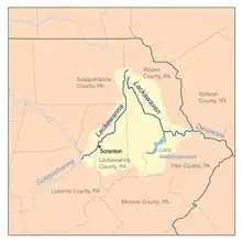 拉克萬納河流域 | |
| 别名 | Gachanai,[1] Hazirok[1] L'chau-hanne,[2] Lackawannok,[3] Lechau-hanné,[4] Lechau-hannek,[2] Lechauwah-hannek.[2] |
| 國家 | |
| 州 | |
| 縣 | 拉克瓦納縣、路澤恩縣、薩斯奎漢納縣和韋恩縣[5] |
| 流域 | |
| 源頭 | 東西側支流合流点 |
| - 海拔 | 1,341英尺(409米) |
| 第二源头 | |
| - 位置 | 東側支流:[5] Bone Pond,[6] Dunn Pond,[7] Independent Lake,[8] Lake Lorain[9] |
| - 海拔 | 東側支流:1,572英尺(479米)[10] |
| 第三源头 | |
| - 位置 | 西側支流:[5] Fiddle Lake,[11] Lewis Lake,[12] Lake Lowe[13] |
| - 海拔 | 西側支流:1,575英尺(480米)[14] |
| 河口 | |
- 位置 | 薩斯奎哈納河北側支流[15] |
- 座標 | 41°20′28″N 75°47′35″W |
- 海拔 | 540英尺(160米) |
| 面積 | 350 sq mi(910 km2)[5] |
| 本貌 | |
| 長度 | 42 mi(68 km)[5] |
| 特徵 | |
| 支流 | |
参考文献
- Craft, David. . Dayton: United Brethren Publishing House. 1891: 34 [1 December 2014].
- Craft. p. 18.
- Mahr, August C. . Ohio Journal of Science (Ohio Academy of Science). November 1959, 59 (6): 368. hdl:1811/4658.
- Trumbull, J. Hammond. . Hartford: Press of Case, Lockwood & Brainard. 1870: 12 [1 December 2014]. (原始内容存档于2012-11-09).
- McGurl, Bernard. Arthur Popp , 编. (PDF) (报告). Daniel Townsend, PhD, Len Gorney, Dominic Totaro, Jack McDonough, Pamela Lomax, Deilsie Heath Kulesa 2. The Lackawanna River Corridor Association: 1. 2002 [17 November 2014]. (原始内容 (PDF)存档于2016-03-05).
- . 美国地质局地理名称信息系统. 2 August 1979.
- . Geographic Names Information System. United States Geological Survey. 2 August 1979.
- . Geographic Names Information System. United States Geological Survey. 2 August 1979.
- . Geographic Names Information System. United States Geological Survey. 2 August 1979.
- . Geographic Names Information System. United States Geological Survey. 2 August 1979.
- . Geographic Names Information System. United States Geological Survey. 2 August 1979.
- . Geographic Names Information System. United States Geological Survey. 2 August 1979.
- . Geographic Names Information System. United States Geological Survey. 2 August 1979.
- . Geographic Names Information System. United States Geological Survey. 2 August 1979.
- McGurl. p. 2.
- . 美国地质局地理名称信息系统. 2 August 1979.
- McGurl. p. 20.
- U.S. Geological Survey. National Hydrography Dataset high-resolution flowline data. The National Map (页面存档备份,存于), accessed August 8, 2011
- Gannett, Henry. . Government Printing Office. 1905: 178 [2018-01-17]. (原始内容存档于2016-06-23).
另请参阅
外部链接
- 美国地质调查:PA流测量站 (页面存档备份,存于)
- 莱卡瓦纳河的走廊协会 (页面存档备份,存于)
This article is issued from Wikipedia. The text is licensed under Creative Commons - Attribution - Sharealike. Additional terms may apply for the media files.