格連堡 (布碌崙)
格連堡(英語:)是美國紐約州紐約市布碌崙區西北部的一個社區。該社區北至法拉盛大道及布碌崙造船廠,西至法烈布殊大道延長段及布碌崙下城,南至大西洋大道和及光景嶺,東至范德堡大道和克林頓山。
| 格連堡 Fort Greene | |
|---|---|
| 社區 | |
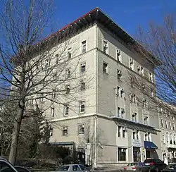 歷史建築,位於南牛津街144號 | |
在紐約市的位置 | |
| 坐标:40.687°N 73.975°W | |
| 國家 | |
| 州份 | |
| 城市 | |
| 行政區 | |
| 社區 | 布碌崙第2區[1] |
| 語源 | 格連將軍建造的一座堡壘 |
| 面积 | |
| • 总计 | 1 平方公里(0.548 平方英里) |
| 人口(2010)[2] | |
| • 總計 | 28,335人 |
| 族裔[3] | |
| • 白人 | 52% |
| • 黑人 | 20% |
| • 西語裔 | 12% |
| • 亞裔 | 11% |
| • 其他 | 4% |
| 經濟 | |
| • 入息中位數 | $57,815 |
| 时区 | EST(UTC−5) |
| • 夏时制 | EDT(UTC−4) |
| 郵區編號 | 11238, 11201, 11205, 11217 |
| 電話區號 | 718, 347, 929, 917 |
參考
- . communityprofiles.planning.nyc.gov. New York City Department of City Planning. [March 18, 2019]. (原始内容存档于2022-09-02).
- Table PL-P5 NTA: Total Population and Persons Per Acre – New York City Neighborhood Tabulation Areas*, 2010 的存檔,存档日期June 10, 2016,., Population Division – New York City Department of City Planning, February 2012. Accessed June 16, 2016.
- Table PL-P3A NTA: Total Population by Mutually Exclusive Race and Hispanic Origin – New York City Neighborhood Tabulation Areas*, 2010 的存檔,存档日期June 10, 2016,., Population Division – New York City Department of City Planning, March 29, 2011. Accessed June 14, 2016.
- McCullough, D. 1776.
延伸閱讀
- Lockwood, Charles, Bricks and Brownstone, The New York Townhouse 1783–1928, Abbeville Press, 1988. ISBN 0-8478-2522-1.
- Morrone, Francis, An Architectural Guidebook to Brooklyn, Gibbs Smith, Publisher, 2001. ISBN 1-58685-047-4.
- History of Fort Greene. Retrieved May 9, 2006.
- Former resident Colson Whitehead writes about Fort Greene gentrification 的存檔,存档日期May 11, 2020,.
外部連結
This article is issued from Wikipedia. The text is licensed under Creative Commons - Attribution - Sharealike. Additional terms may apply for the media files.