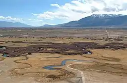
欧文斯谷
欧文斯谷(英語:)是美国加利福尼亚州东部欧文斯河气候干旱的河谷,位于內華達山脈以东、白山山脉和因约山脉以西、大盆地的西缘处。两侧的山峰(包括惠特尼峰)都达到了海拔14,000英尺(4,300)以上,而欧文斯谷的谷底的海拔则只有4,000英尺(1,200),使得该河谷成为美国最深的峡谷之一。[2]
| 欧文斯谷 Owens Valley | |
|---|---|
 欧文斯河 | |
| 最低海拔 | 4,000英尺(1,200) |
| 长度 | 75英里(121) 南北向 |
| 地理 | |
| 人口中心 | 毕晓普、隆派恩、独立城、大派恩 |
| 边界 | 因约山脉(东) 科首山(东南) Rose Valley (南) 內華達山脈 (西) 夏芬谷(北)[1] |
| 坐标 | 36°48′09″N 118°11′59″W |
| 道路 | 395号美国国道 |
| 河流 | 欧文斯河 |
外部链接
| 维基共享资源上的相关多媒体资源:欧文斯谷 |
- The Owens Valley Committee: The Owens Valley, (Valle Nevado (页面存档备份,存于))
- Cenozoic/Mesozoic Volcanism of the Eastern Sierra Nevada
- Groundwater Quality in the Owens Valley, California (页面存档备份,存于) United States Geological Survey
- Lower Owens River Project - 60-英里(97-) restoration of the lower owens river
- Inyo County Water Department (页面存档备份,存于)
- Eval. of the Hydrologic System and Selected Water-Management Alternatives in the Owens Valley, California (页面存档备份,存于)
- Roadside Geology and Mining History of the Owens Valley and Mono Basin
参考资料
- . 美国地质局地理名称信息系统. [2009-05-03].
- Smith, Genny; Jeff Putnam. 2nd. Genny Smith books. Sierra Club. 1976. ISBN 0-931378-14-1.
This article is issued from Wikipedia. The text is licensed under Creative Commons - Attribution - Sharealike. Additional terms may apply for the media files.