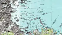
波士頓灣
參考資料
- Boston Harbor Islands National Recreation Area - Massachusetts (页面存档备份,存于), U.S. National Park Service
外部連結
| 维基共享资源上的相关多媒体资源:波士頓灣 |
- Save the Harbor / Save the Bay (页面存档备份,存于)
- The Boston Harbor Association (页面存档备份,存于)
- Boston Harbor resources site (页面存档备份,存于)
- NOAA Soundings Map of Boston Harbor (页面存档备份,存于)
- Flickr.com (页面存档备份,存于), Photos, January 2009.
- Flickr.com (页面存档备份,存于), Photos, November 2009.
- Flickr.com (页面存档备份,存于), Photos, February 2010.
- Dutton, E.P. Chart of Boston Harbor and Massachusetts Bay with Map of Adjacent Country. (页面存档备份,存于) Published 1867. A good map of a proposed build-out of infrastructure into the Boston Harbor.
This article is issued from Wikipedia. The text is licensed under Creative Commons - Attribution - Sharealike. Additional terms may apply for the media files.
