温德河山脉
温德河山脉(英語:)是美国西怀俄明州洛磯山脈的一支子脉,走向为西北-东南,绵延100英里(160)。大陆分水岭沿着该山脉的山冠前行,其中有怀俄明州的最高点——甘尼特峰,高13,804英尺(4,207)。除此之外,温德河山脉还有超过40座海拔13,000英尺(4,000)的山脉。除了蒂顿山脉的大蒂顿峰()外,怀俄明州接下来的19座最高峰也同样位于温德河山脉之中。[1]温德河山脉由两座大型国家森林、三片原野地区构成。其中,肖松尼国家森林位于大陆分水岭东边,布里杰-蒂顿国家森林在其西边。这两座国家森林,以及整座山脉,都是大黄石生态系统的一部分。此外,温德河山脉有一部分位于温德河印第安保护区内。
| 温德河山脉 | |
|---|---|
 温德河山脉高地 | |
| 最高点 | |
| 山峰 | 甘尼特峰 |
| 海拔 | 13,804英尺(4,207) |
| 43°11′04″N 109°39′12″W | |
| 规模 | |
| 长度 | 100英里(160) NW/SE |
| 宽度 | 30英里(48) SW/NE |
| 面积 | 2,800平方英里(7,300平方) |
| 地理 | |
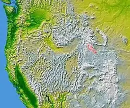
 The Wind River Range highlighted in pink
| |
| 国家 | |
| 州或邦 | 怀俄明州 |
| 山脈 | 落基山脉 |
参考资料
- . Peakbagger. [2007-04-06]. (原始内容存档于2021-01-22).
外部链接
| 维基共享资源上的相关多媒体资源:温德河山脉 |
- Shoshone National Forest Federal website (页面存档备份,存于)
- Bridger-Teton National Forest Federal website (页面存档备份,存于)
- General Information on the Wind River Mountains (页面存档备份,存于)
- Wyoming Tourism information
- Continental Divide Trail information (页面存档备份,存于)
- Article discussing glacial retreat in the Wind River Range
- Glaciers shrinking (页面存档备份,存于)
This article is issued from Wikipedia. The text is licensed under Creative Commons - Attribution - Sharealike. Additional terms may apply for the media files.