于登
于登(荷蘭語:,荷兰语发音:[ˈydə(n)] (ⓘ))是荷蘭的一個市鎮,位於荷蘭南部,在行政區劃上屬於北布拉班特省。于登首次出現在文獻記載是在1190年。
| 于登 Uden | |||
|---|---|---|---|
| 市镇 | |||
 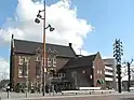 .JPG.webp)  左上:圣伯多禄教堂;右上:旧市政厅 左下:伯达夫山沙丘;右下:福尔克尔空军基地 | |||
| |||
.svg.png.webp) 于登在北布拉班特省的位置 | |||
| 坐标:51°39′N 5°37′E | |||
| 國家 | |||
| 省份 | 北布拉班特省 | ||
| 政府[1] | |||
| • 行政机构 | 市议会 | ||
| • 市长 | Henk Hellegers (PvdA) | ||
| 面积[2] | |||
| • 市镇 | 67.53 平方公里(26.07 平方英里) | ||
| • 陸地 | 67.00 平方公里(25.87 平方英里) | ||
| • 水域 | 0.53 平方公里(0.20 平方英里) | ||
| 海拔[3] | 16 公尺(52 英尺) | ||
| 人口(市镇, 20191月; 城市区, 2010年1月; 都会区, 2014年1月)[4][5][6] | |||
| • 市镇 | 41,782人 | ||
| • 密度 | 624人/平方公里(1,620人/平方英里) | ||
| • 城市区 | 40,535 | ||
| • 城市区密度 | 2,391人/平方公里(6,190人/平方英里) | ||
| • 都会区 | 161,900 | ||
| 居民称谓 | Udenaar | ||
| 时区 | CET(UTC+1) | ||
| • 夏时制 | CEST(UTC+2) | ||
| 邮政编码 | 5400–5409 | ||
| 电话区号 | 0413 | ||
| 網站 | www | ||


參考資料
- . Gemeente Uden. [2014-06-05]. (原始内容存档于2014-07-14) (荷兰语).
- [地区关键统计数字]. 荷蘭中央統計局统计数据. 荷蘭中央統計局. 2013-07-02 [2014-03-12] (荷兰语).
- . Actueel Hoogtebestand Nederland. Het Waterschapshuis. [2014-06-05]. (原始内容存档于2018-12-25) (荷兰语).
- [Population growth; regions per month]. 荷蘭中央統計局统计数据. 荷蘭中央統計局. 1 January 2019 [2019年1月1日] (荷兰语).
- [Key figures for neighbourhoods 2010]. CBS Statline; Urban area. CBS. 2010-01-01 [2014-12-10]. (原始内容存档于2019-01-02) (荷兰语).
- [Key figures for neighbourhoods 2014]. CBS Statline; Metro region. CBS. 2014-01-01 [2015-09-02]. (原始内容存档于2019-01-02) (荷兰语).
外部連結
 维基共享资源上的相關多媒體資源:于登
- Official website(页面存档备份,存于)
This article is issued from Wikipedia. The text is licensed under Creative Commons - Attribution - Sharealike. Additional terms may apply for the media files.