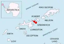
發現號灣
發現號灣
(
英語:
)是
南極洲
的
海灣
,位於
南設得蘭群島
的
格林尼治島
北部,長5公里、寬3公里,該海灣在1935年被
英國
探險隊繪入地圖,現時由
南極條約體系
管理。
[1]
[2]
参考文献
.
美国地质局
地理名称信息系统.
(PDF)
. Management Plan for Antarctic Specially Protected Area No. 144: Measure 4. Antarctic Treaty Secretariat. 2005
[
2013-09-29
]
. (
原始内容
(PDF)
存档于2015-09-23).
This article is issued from
Wikipedia
. The text is licensed under
Creative Commons - Attribution - Sharealike
. Additional terms may apply for the media files.