富纳富提
富纳富提(Funafuti),是图瓦卢首都,人口6025人(2016年)[1]。
| 富纳富提 Funafuti | |
|---|---|
| 城镇 | |
 | |
 富纳富提环礁的空拍照 | |
 富纳富提 富纳富提环礁的空拍照 | |
| 坐标:8°30′17″S 179°07′02″E | |
| 国家 | |
| 面积 | |
| • 总计 | 2.4 平方公里(0.9 平方英里) |
| 人口(2016)[1] | |
| • 總計 | 6,025人 |
| • 密度 | 2,510人/平方公里(6,502人/平方英里) |
| ISO 3166码 | TV-FUN |
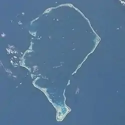
富纳富提建于一组环礁上,是图瓦卢全国9组环礁中规模最大的一组。方圓不超過2平方公里。
歷史

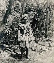
富納富提一女性住民(1900)
第一個拜訪富納富提的白人是來自紐約並擔任英國海軍艦長的亞倫特·束勒·皮賽德。[4]亞倫特·束勒·皮賽德於1819年5月經過吐瓦魯南方時發現了富納富提,當時他以一名英國政治家愛德華·艾利斯之名命名此地。(巴巴艾利斯)[5]
由查爾斯·維克斯所帶領的美國國家探險隊於1841年到達富納富提。[6]
地理
氣候
根據柯本氣候分類法,富納富提屬熱帶雨林氣候,溫度變化小,各月份均溫皆約為28°C,且全年多雨,每個月皆有超過200毫米的降水,並無乾季。
| 富納富提 平均溫度1981–2000、極端溫度1936–2000 、平均降水1951–1990 、平均降水日1947–1990 、 平均濕度1961–1990、平均日照1978–1990 | |||||||||||||
|---|---|---|---|---|---|---|---|---|---|---|---|---|---|
| 月份 | 1月 | 2月 | 3月 | 4月 | 5月 | 6月 | 7月 | 8月 | 9月 | 10月 | 11月 | 12月 | 全年 |
| 历史最高温 °C(°F) | 33.8 (92.8) |
34.4 (93.9) |
34.4 (93.9) |
33.2 (91.8) |
33.9 (93.0) |
33.9 (93.0) |
32.8 (91.0) |
32.9 (91.2) |
32.8 (91.0) |
34.4 (93.9) |
33.9 (93.0) |
33.9 (93.0) |
34.4 (93.9) |
| 平均高温 °C(°F) | 30.7 (87.3) |
30.8 (87.4) |
30.6 (87.1) |
31.0 (87.8) |
30.9 (87.6) |
30.6 (87.1) |
30.4 (86.7) |
30.4 (86.7) |
30.7 (87.3) |
31.0 (87.8) |
31.2 (88.2) |
31.0 (87.8) |
30.8 (87.4) |
| 日均气温 °C(°F) | 28.2 (82.8) |
28.1 (82.6) |
28.1 (82.6) |
28.2 (82.8) |
28.4 (83.1) |
28.3 (82.9) |
28.1 (82.6) |
28.1 (82.6) |
28.2 (82.8) |
28.2 (82.8) |
28.4 (83.1) |
28.3 (82.9) |
28.2 (82.8) |
| 平均低温 °C(°F) | 25.5 (77.9) |
25.3 (77.5) |
25.4 (77.7) |
25.7 (78.3) |
25.8 (78.4) |
25.9 (78.6) |
25.7 (78.3) |
25.8 (78.4) |
25.8 (78.4) |
25.7 (78.3) |
25.8 (78.4) |
25.7 (78.3) |
25.8 (78.4) |
| 历史最低温 °C(°F) | 22.0 (71.6) |
22.2 (72.0) |
22.8 (73.0) |
23.0 (73.4) |
20.5 (68.9) |
23.0 (73.4) |
21.0 (69.8) |
16.1 (61.0) |
20.0 (68.0) |
21.0 (69.8) |
22.8 (73.0) |
22.8 (73.0) |
16.1 (61.0) |
| 平均降水量 mm() | 413.7 (16.29) |
360.6 (14.20) |
324.3 (12.77) |
255.8 (10.07) |
259.8 (10.23) |
216.6 (8.53) |
253.1 (9.96) |
275.9 (10.86) |
217.5 (8.56) |
266.5 (10.49) |
275.9 (10.86) |
393.9 (15.51) |
3,512.6 (138.29) |
| 平均降水天数(≥ 1.0 mm) | 20 | 19 | 20 | 19 | 18 | 19 | 19 | 18 | 16 | 18 | 17 | 19 | 223 |
| 平均相對濕度(%) | 82 | 82 | 82 | 82 | 82 | 82 | 83 | 82 | 81 | 81 | 80 | 81 | 82 |
| 月均日照時數 | 179.8 | 161.0 | 186.0 | 201.0 | 195.3 | 201.0 | 195.3 | 220.1 | 210.0 | 232.5 | 189.0 | 176.7 | 2,347.7 |
| 日均日照時數 | 5.8 | 5.7 | 6.0 | 6.7 | 6.3 | 6.7 | 6.3 | 7.1 | 7.0 | 7.5 | 6.3 | 5.7 | 6.4 |
| 来源:Deutscher Wetterdienst[7] | |||||||||||||
組成島嶼
富納富提至少由33個珊瑚礁島嶼所組成。
參考
- . Thomas Brinkhoff. 11 April 2012 [20 March 2016]. (原始内容存档于2016-03-24).
- Talakatoa OBrien. . Institute of Pacific Studies, University of the South Pacific and Government of Tuvalu. 1983.
- Donald G. Kennedy, "Field Notes on the Culture of Vaitupu, Ellice Islands" (页面存档备份,存于), Journal of the Polynesian Society, vol.38, 1929, pp.2-5
- Miscellanies: by an officer, Volume 1, Ch. LXXX By John Watts De Peyster, A.E. Chasmer & Co. (1888)
- Laumua Kofe, Palagi and Pastors, Tuvalu: A History, Ch. 15, Institute of Pacific Studies, University of the South Pacific and Government of Tuvalu, 1983
- Tyler, David B. - 1968 The Wilkes Expedition. The First United States Exploring Expedition (1838-42). Philadelphia: American Philosophical Society
- (PDF). Baseline climate means (1961–1990) from stations all over the world. Deutscher Wetterdienst. [22 November 2016] (德语).
This article is issued from Wikipedia. The text is licensed under Creative Commons - Attribution - Sharealike. Additional terms may apply for the media files.