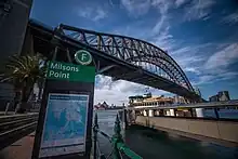
米爾遜角
米爾遜角(英語:),澳大利亞新南威爾士州首府悉尼下北岸的一個商住混合區,位於悉尼海港大橋的北端,毗鄰北悉尼,與悉尼中心商業區只是一岸之隔。自1788年起有白人在這裡居住。米爾遜角亦得名自首批定居者中的詹姆斯·米爾遜(James Milson)。

歷史
米爾遜角得名于來自英國林肯郡的自由定居者(free settler)詹姆斯·米爾遜。在1820年代初期[1],他向羅伯特·坎貝爾(Robert Campbell)租用了120 acre(49 ha)的土地栽種蔬果及飼養牲口,向往來的船隻售賣石碴、食水及其他補給糧食[2]。在1824年,他獲授予相鄰的50 acre(20 ha)的土地[3]。1831年,米爾遜和坎貝爾曾經因為租務的糾紛對簿公堂[2]。至1840年代,米爾遜向坎貝爾租用的土地面積減少至現杰弗里街(Jeffrey Street)一帶[4]。1872年,米爾遜在家中去世[5],其家族繼續在該處持有物業,至1920年代被收回以興建悉尼海港大橋[6]。
參考
- (PDF). North Sydney Historical Society. 1994 [28 January 2013]. (原始内容 (PDF)存档于27 February 2012).
- . The Sydney Monitor, Wednesday 5 October 1831, p.2. [28 January 2013].
- . Fiche 3269; 9/2740 p.19. Colonial Secretary’s Papers, 1788-1825 (held in State Records of New South Wales). 10 August 1824 [28 January 2013]. (原始内容存档于25 April 2013).
- (地图). Scale indeterminable. [184-?]. Map of peninsula at North Sydney showing leases, roads, weather board cottages, jetties, wells, orchards, bee hives, barns, milking bails and stables and the graves of the three typhoid victims from the Surry. inset. 1840–1849 [2023-06-21]. Amicus Number: 8560781. (原始内容存档于2011-06-29).
- . Empire: 1. 28 October 1872 [28 January 2013].
- Pollon, Frances (编). . Australia: Angus & Robertson Publishers. 1990: 174. ISBN 0-207-14495-8.
外部連結
| 维基共享资源上的相关多媒体资源:米爾遜角 |
- Margaret Park. . Dictionary of Sydney. 2008 [28 September 2015]. (原始内容存档于2014-02-03). [CC-By-SA]
This article is issued from Wikipedia. The text is licensed under Creative Commons - Attribution - Sharealike. Additional terms may apply for the media files.