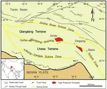
羌塘地块
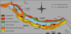
喜马拉雅山脉的大地构造图,修正自Le Fort & Cronin (1988)。红色是跨喜马拉雅带。绿色是印度河-雅鲁藏布江缝合带,其北部是拉萨地块,再向北是班公湖-怒江缝合带和羌塘地块。
金沙江缝合带反映三叠纪时羌塘地块北缘向南,潜没到松潘-甘孜地块下方。在侏罗纪,拉萨地体与羌塘地块的南缘沿班公湖缝合带熔合。[1]:Geologic setting, p. 475这一缝合带也是特提斯洋的闭合线,使羌塘地块变成了巨大的背斜。[2]:Geologic setting, pp. 32–33
羌塘地块目前海拔约5km,不过其抬升的具体时间存在争议,从上新世-更新世(3–5 Ma)到始新世(35 Ma)的估计都有。后者的估计基于高原第一次遭受剥蚀作用的时间。[2]:Introduction, pp. 31–32
参考
资料
- Wang, Q.; Wyman, D. A.; Xu, J.; Wan, Y.; Li, C.; Zi, F.; Jiang, Z.; Qiu, H.; Chu, Z.; Zhao, Z.; Dong, Y. . Contributions to Mineralogy and Petrology. 2008, 155 (4) [1 January 2020]. Bibcode:2008CoMP..155..473W. S2CID 140614302. doi:10.1007/s00410-007-0253-1.:473–490
- Xu, Q.; Ding, L.; Zhang, L.; Cai, F.; Lai, Q.; Yang, D.; Liu-Zeng, J. (PDF). Earth and Planetary Science Letters. 2013, 362 [1 January 2020]. Bibcode:2013E&PSL.362...31X. doi:10.1016/j.epsl.2012.11.058.:31–42
This article is issued from Wikipedia. The text is licensed under Creative Commons - Attribution - Sharealike. Additional terms may apply for the media files.