莫农加希拉国家森林
莫农加希拉国家森林(英語:)是美国西弗吉尼亚州的一座国家森林,位于阿勒格尼山脉以东[3]。
| Monongahela National Forest | |
| 美国国家森林 | |
[[File: MonNatForest.jpg|256px|none|View from the slopes of Back Allegheny Mountain looking east. Visible are 阿勒格尼山脉 (middle distance) and Shenandoah Mountain (far distance). 远方是弗吉尼亚州的乔治·华盛顿和杰斐逊国家森林 {{|}}]] View from the slopes of Back Allegheny Mountain looking east. Visible are 阿勒格尼山脉 (middle distance) and Shenandoah Mountain (far distance). 远方是弗吉尼亚州的乔治·华盛顿和杰斐逊国家森林 | |
| 名称起源:莫农加希拉河,流域的大部分为此原始森林 | |
| 国家 | |
|---|---|
| 省/州/邦 | |
| 县[1] | 格蘭特縣、格林布賴爾縣、尼古拉斯縣、彭德爾頓縣、波卡洪塔斯縣、普雷斯頓縣、蘭道夫縣、塔克縣、韋伯斯特縣 |
| Ranger Districts[1] | Cheat-Potomac、Greenbrier、Marlinton-White Sulphur Springs、Gauley |
| 最高點 | 斯普鲁斯丘 |
| - 位置 | 西弗吉尼亚州彭德爾頓縣 |
| - 海拔 | 4,863 ft(1,482.2 m) |
| 最低点 | 波托马克河南支 |
| - 位置 | 西弗吉尼亚州Petersburg以西 |
| - 海拔 | 968 ft(295 m) |
| 面积 | 921,150 英亩(372,776 公顷)[2] |
| - Proclamation Boundary | 1,706,898 英亩(690,757 公顷)[2] |
| Established | 1920年4月28日 |
| - Monongahela Purchase | 1915年 |
| 所有者 | 美国国家森林局 |
| IUCN保护区分类 | VI - 资源管理保护区 |
| Headquarters | 西弗吉尼亚州Elkins |
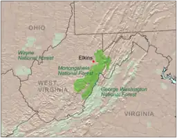
 莫农加希拉国家森林的位置
| |
| 维基共享资源:Monongahela National Forest | |
| 网站:Monongahela National Forest | |
参考文献
引文
其他来源
- 马金,C.R.(1970), 莫农加希拉的国家森林历史中,未发表的手稿,可在莫农加希拉的国家森林办公室, 埃尔金斯,西弗吉尼亚州.
- de Hart,艾伦和布鲁Sundquist(2006年)、 莫农加希拉的国家森林里徒步旅行指南,第8版, 西弗吉尼亚高原的保护, Charleston的,西弗吉尼亚州.
- Berman,Gillian梅斯梅丽莎康利-Spencer,Barbara J.豪尔和夏琳用(1992年)、 莫农加希拉的国家森林:1915-1990,Morgantown、西弗吉尼亚州:西弗吉尼亚公众的历史记录的程序;为联合国森林服务:莫农加希拉的国家森林。 (March1992)
- DeMeo,汤姆和Julie康坎农(1996年),"在星期一:图像和物质在西弗吉尼亚州的国家森林"的, 内心的声音,第一卷。 8时,问题1,January/February.
- 曼德尼(1977年), 经验教训,从莫农加希拉的经验,美国农业部、森林服务。
- 这篇文章中包含的信息,最初来自美国政府出版物和网站,并在公共领域。
外部链接
This article is issued from Wikipedia. The text is licensed under Creative Commons - Attribution - Sharealike. Additional terms may apply for the media files.