莱茵沃德
莱茵沃德(荷蘭語:,荷兰语:[ˈrɛinˌʋɑu̯də] (ⓘ))是荷兰南荷兰省的一个旧市镇。2004年人口18,986。面积57.85 km²,其中1.17 km²为水域。2014年1月1日,莱茵沃德同市镇博斯科普并入市镇莱茵河畔阿尔芬。
| 莱茵沃德 Rijnwoude | |||
|---|---|---|---|
| 旧市镇 | |||
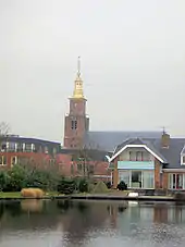 哈泽斯沃德-多普的教堂 | |||
| |||
.svg.png.webp) 莱茵沃德在南荷兰省的位置 | |||
| 坐标:52°8′N 4°35′E | |||
| 国家 | |||
| 省份 | 南荷兰省 | ||
| 市镇 | 莱茵河畔阿尔芬 | ||
| 成立 | 1991年1月1日 | ||
| 撤销 | 20141月1日[1] | ||
| 面积[2] | |||
| • 总计 | 57.89 平方公里(22.35 平方英里) | ||
| • 陸地 | 56.69 平方公里(21.89 平方英里) | ||
| • 水域 | 1.20 平方公里(0.46 平方英里) | ||
| 海拔[3] | −1 公尺(−3 英尺) | ||
| 人口(2013年11月)[4] | |||
| • 總計 | 18,523人 | ||
| • 密度 | 327人/平方公里(850人/平方英里) | ||
| 时区 | CET(UTC+1) | ||
| • 夏时制 | CEST(UTC+2) | ||
| 邮政编码 | 2390–2396, 2730–2731 | ||
| 行政区划 | 0172, 071, 079 | ||

图集
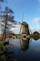 风车 |
|
外部链接
| 维基共享资源上的相关多媒体资源:莱茵沃德 |
- [Municipal divisions on 1 January 2014]. cbs.nl. CBS. [10 January 2014]. (原始内容存档于2016-03-04) (荷兰语).
- [Key figures for neighbourhoods]. CBS Statline. CBS. 2 July 2013 [11 July 2013]. (原始内容存档于1999-04-27) (荷兰语).
- . Actueel Hoogtebestand Nederland. Het Waterschapshuis. [19 August 2013]. (原始内容存档于2018-12-24) (荷兰语).
- [Population growth; regions per month]. CBS Statline. CBS. 23 December 2013 [20 January 2014]. (原始内容存档于2018-10-03) (荷兰语).
This article is issued from Wikipedia. The text is licensed under Creative Commons - Attribution - Sharealike. Additional terms may apply for the media files.