西阿爾卑斯山脈
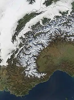
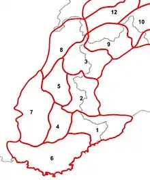
西阿爾卑斯山脈是歐洲的山脈,是阿爾卑斯山脈的西面部分,橫跨摩納哥、法國東南部、意大利西北部和瑞士西南部,長300公里、寬150公里,最高點白朗峰海拔高度4,810米。
| 西阿爾卑斯山脈 | |
|---|---|
 | |
| 最高点 | |
| 山峰 | 白朗峰 |
| 海拔 | 4,810(15,780英尺) |
| 45°50′01″N 06°51′54″E | |
| 规模 | |
| 长度 | 300(190英里) [1] |
| 宽度 | 150至185 km(93至115 mi) |
| 地理 | |
 The Western Alps from space
| |
| 国家 | 摩納哥、法國、意大利和瑞士 |
| 山脈 | 阿爾卑斯山脈 |
| 边界 | List
|
| 地质 | |
| 造山运动 | 阿爾卑斯山脈 |

与东阿尔卑斯山相比,山峰和山口更高,而山脉本身并不那么宽,也更像拱形。
參考文獻
- Umlauft, Friedrich. . K. Paul, Trench & Company. 1889: 78.
外部連結
- Italian official cartography (Istituto Geografico Militare - IGM); on-line version: www.pcn.minambiente.it(页面存档备份,存于)
- French official cartography (Institut Géographique National - IGN); on-line version: www.geoportail.fr(页面存档备份,存于)
- Swiss official cartography (Swiss Federal Office of Topography - Swisstopo); on-line version: map.geo.admin.ch(页面存档备份,存于)
This article is issued from Wikipedia. The text is licensed under Creative Commons - Attribution - Sharealike. Additional terms may apply for the media files.