红河 (密西西比河)
雷德河[2](英語:),也译作“红河”,是密西西比河下游西岸的主要支流之一。
| 雷德河 Red River Bah'hatteno[1] | |
| Rivière Rouge (former French name) | |
| River | |
[[File: redriverbonhamtx.jpg|240pxpx|none|Red River looking east, north of Bonham, Texas:
Texas is to the right, Oklahoma is on the left, and the border between the two states runs along the south (right) bank of the river. {{|}}]] Red River looking east, north of Bonham, Texas:
Texas is to the right, Oklahoma is on the left, and the border between the two states runs along the south (right) bank of the river. | |
| 国家 | |
|---|---|
| 省/州/邦 | |
| 屬於 | 密西西比河流域 |
| 源头 | Confluence of Prairie Dog Town Fork and Buck Creek |
| - 位置 | 哈蒙縣 |
| - 海拔 | 1,535 ft(468 m) |
| - 坐标 | 34°34′35″N 99°57′54″W |
| 河口 | Atchafalaya/密西西比河 |
| - 位置 | 西费利西亚纳堂区 |
| - 海拔 | 30 ft(9 m) |
| - 坐标 | 31°01′10″N 91°44′52″W |
| 长度 | 1,360 mi(2,189 km) |
| 流域面积 | 65,595 mi²(169,890 km²) |
| 流量 | 平均值测于河口,最大值与最小值测于亚历山德里亚 |
| - 平均流量 | 57,000 ft³/s(1,614 m³/s) |
| - 最大流量 | 233,000 ft³/s(6,598 m³/s) |
| - 最小流量 | 1,472 ft³/s(42 m³/s) |
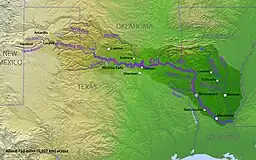
 雷德河流域图
| |
雷德河发源于得克萨斯州西北部地区,有两支主要源头,合流后向东流去,成为得克萨斯和俄克拉何马州的边界。之后,雷德河流入阿肯色州,然后折向南,在路易斯安那州汇入密西西比河,全长2189公里。
参考文献
- Caddo name. Meredith, Howard. "Caddo (Kadohadacho)." 的存檔,存档日期2010-07-19. Oklahoma Historical Society's Encyclopedia of Oklahoma History and Culture. Retrieved 9 Sept 2012)
- 民政部地名研究所 (编). . . 北京: 中国社会出版社: 2358. 2017-05. ISBN 978-7-5087-5525-0. OCLC 1121629943. OL 28272719M. NLC 009152391.(简体中文)
外部链接
- 雷德河考察,作者兰多夫·马西,1852年
This article is issued from Wikipedia. The text is licensed under Creative Commons - Attribution - Sharealike. Additional terms may apply for the media files.