马尔特诺马瀑布
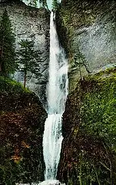
马尔特诺马瀑布[1](英語:),或马特诺玛瀑布,是位于哥伦比亚河峡谷南岸(俄勒冈州方向)的一个瀑布。瀑布主要分为两段,其中一段在542英尺(165)处,紧接着的一段在69英尺(21)处,两段瀑布中间有一段9英尺(3米)的斜坡,因此一般认为整个瀑布的落差为620英尺(189)。马尔特诺马瀑布是俄勒冈州落差最大的瀑布。瀑布附近有一个标志,上面标记着该瀑布是美国第二高的全年性瀑布,不过有瀑布方面的专家反对这一说法。[2]

The Multnomah Creek Bridge on the Historic Columbia River Highway.
Colorized picture of the waterfall before the footbridge was added
| 马尔特诺马瀑布 | |
|---|---|
 两段瀑布的秋景 | |
| 位置 | |
| 座標 | 45.5759516°N 122.1153641°W |
| 类型 | Tiered |
| 海拔 | 627英尺(191米) |
| 高度 | 620英尺(189米) |
| 瀑布數 | 2 |
| 最大落差 | 542英尺(165米) |
| 平均寬度 | 10英尺(3米) |
| 水系 | Multnomah Creek |
| 平均流速 | 150 cu ft/s(4.2 m3/s) |
| 世界落差排名 | 434 |
参考文献
- 民政部地名研究所 (编). . . 北京: 中国社会出版社: 1894. 2017-05. ISBN 978-7-5087-5525-0. OCLC 1121629943. OL 28272719M. NLC 009152391.(简体中文)
- . World Waterfall Database. 2004 [August 1, 2011]. (原始内容存档于2011-09-30).
外部链接
| 维基共享资源上的相关多媒体资源:马尔特诺马瀑布 |
- Multnomah Falls (页面存档备份,存于) and Welcome to Multnomah Falls (页面存档备份,存于), from a USFS website
- Multnomah Falls from the Oregon Tourism Commission
- Built in America: Columbia River Highway, from a Library of Congress website
- Historic Columbia River Highway
- Old Postcards of Multnomah Falls
- Hiking Multnomah Falls (页面存档备份,存于)
- Excerpt from Historic American Engineering Record report on Benson Footbridge (页面存档备份,存于)
- Native American Legend: Coyote and Multnomah Falls (页面存档备份,存于)
Template:Waterfalls of Oregon Template:Protected Areas of Oregon
This article is issued from Wikipedia. The text is licensed under Creative Commons - Attribution - Sharealike. Additional terms may apply for the media files.