特羅布里恩群島
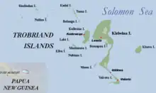
特羅布里恩群島[1](英語:),或譯超布連群島[2]、初步蘭群島[3],是巴布亞新幾內亞的群島,位於該國東面所羅門海,由四個主要島嶼組成,行政方面由米爾恩灣省負責管轄,總面積450平方公里。1793年法國人首先發現此地,20世紀初布罗尼斯拉夫·马林诺夫斯基曾在此進行田野調查。

地理
該群島共有四個大島,即最大的基里維納島(Kiriwina)和Kaileuna、Vakuta、Kitava三島。基里維纳島長43(27英里),寬度在1至16(0.62至9.94英里)之間不等。1980年代時基里維纳島上有大約60個村落,人口約12,000。其他島嶼的人口向來只有數百。除去基里維纳島之外,各島都是地勢平坦的珊瑚环礁,全年濕熱、多雨。[4]
参考文献
外部連結
- Trobriand Islands Online (页面存档备份,存于)
- Sorcery and Seduction (页面存档备份,存于) The Art of Influence in the Trobriands — A travel story about the Trobriands by Roderick Eime
- (页面存档备份,存于) Lineal and Non-Lineal Codifications of Reality by Dorothy Lee
- Trobriand Islands rain forests (World Wildlife Fund)(页面存档备份,存于)
- Malinowski fieldwork photographs of the Trobriand Islands (1915–18) (页面存档备份,存于) held at London School of Economics Archives (页面存档备份,存于)
This article is issued from Wikipedia. The text is licensed under Creative Commons - Attribution - Sharealike. Additional terms may apply for the media files.