Číměř | |
|---|---|
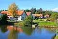
.JPG.webp) General view of Číměř | |
 Flag  Coat of arms | |
 Číměř Location in the Czech Republic | |
| Coordinates: 49°3′38″N 15°4′25″E / 49.06056°N 15.07361°E | |
| Country | |
| Region | South Bohemian |
| District | Jindřichův Hradec |
| First mentioned | 1359 |
| Area | |
| • Total | 45.78 km2 (17.68 sq mi) |
| Elevation | 519 m (1,703 ft) |
| Population (2023-01-01)[1] | |
| • Total | 709 |
| • Density | 15/km2 (40/sq mi) |
| Time zone | UTC+1 (CET) |
| • Summer (DST) | UTC+2 (CEST) |
| Postal codes | 378 02, 378 32, 378 33 |
| Website | www |
Číměř is a municipality and village in Jindřichův Hradec District in the South Bohemian Region of the Czech Republic. It has about 700 inhabitants.
Číměř lies approximately 11 kilometres (7 mi) south-east of Jindřichův Hradec, 46 km (29 mi) east of České Budějovice, and 123 km (76 mi) south-east of Prague.
Administrative parts
Villages of Bílá, Dobrá Voda, Lhota, Nová Ves, Potočná and Sedlo are administrative parts of Číměř.
Gallery
 Centre of Bílá
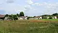 Centre of Nová Ves
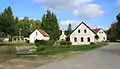 Centre of Potočná
References
Wikimedia Commons has media related to Číměř (Jindřichův Hradec District).
This article is issued from Wikipedia. The text is licensed under Creative Commons - Attribution - Sharealike. Additional terms may apply for the media files.