Černá v Pošumaví | |
|---|---|
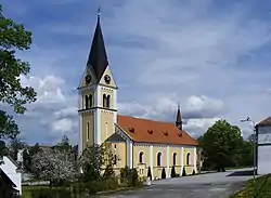
 Church of the Immaculate Conception | |
 Flag  Coat of arms | |
 Černá v Pošumaví Location in the Czech Republic | |
| Coordinates: 48°44′17″N 14°06′38″E / 48.73806°N 14.11056°E | |
| Country | |
| Region | South Bohemian |
| District | Český Krumlov |
| First mentioned | 1268 |
| Government | |
| • Mayor | Irena Pekárková |
| Area | |
| • Total | 50.47 km2 (19.49 sq mi) |
| Elevation | 728 m (2,388 ft) |
| Population (2023-01-01)[1] | |
| • Total | 856 |
| • Density | 17/km2 (44/sq mi) |
| Time zone | UTC+1 (CET) |
| • Summer (DST) | UTC+2 (CEST) |
| Postal codes | 382 23, 382 26 |
| Website | www |
Černá v Pošumaví (until 1950 Černá; German: Schwarzbach) is a municipality and village in Český Krumlov District in the South Bohemian Region of the Czech Republic. It has about 900 inhabitants. It is a popular summer resort.
Administrative parts
Villages of Bližná, Dolní Vltavice, Mokrá, Muckov and Plánička are administrative parts of Černá v Pošumaví.
Etymology
The Czech name Černá (i.e. "black") and the historical German name Schwarzbach (i.e. "black stream") were derived from the stream that flowed below the village. The oldest forms of the name was Natschernerece (literally "on the black river") and Nachirnie. In 1483, the name Czerna first appeared. From 1530, the name Schwarzbach was used in various forms.[2]
Geography
Černá v Pošumaví is located about 17 km (11 mi) southwest of Český Krumlov and 36 km (22 mi) southwest of České Budějovice. The municipal territory borders Germany. It lies in the Bohemian Forest on the shore of the Lipno Reservoir. The highest point is a hill with an elevation of 862 m (2,828 ft).
History
The first written mention of Černá v Pošumaví is in the donation deed of Ottokar II of Bohemia from 1268, who gave the village to his burgrave Hirzo of Klingenberg.[3]
After 1945, some formerly independent municipalities in the territory of today's Černá v Pošumaví were liquidated due to the expulsion of the German population and the modification of the border zone, partly due to the construction of the Lipno Reservoir.[3]
Graphite mining
The first records of the mining of graphite date from the 1760s. Graphite mines were opened by the Schwarzenbergs in 1812. Ink was used for the production of pencils in the Zlatá Koruna and in České Budějovice at the Kooh-i-noor Hardtmuth company. Most of the graphite deposits were flooded by the resrvoir.[3][4]
Demographics
|
|
| ||||||||||||||||||||||||||||||||||||||||||||||||||||||
| Source: Censuses[5][6] | ||||||||||||||||||||||||||||||||||||||||||||||||||||||||
Sights
The main landmark of Černá v Pošumaví is the Church of the Immaculate Conception. It was built in the Baroque style in 1799–1800, when it replaced a wooden chapel from 1787. It was rebuilt into its present Neo-Romanesque form in 1901–1904.[7]
References
- ↑ "Population of Municipalities – 1 January 2023". Czech Statistical Office. 2023-05-23.
- ↑ Profous, Antonín (1947). Místní jména v Čechách I: A–H (in Czech). p. 321.
- 1 2 3 "Černou v Pošumaví najdete tam, kde je Lipno nejširší" (in Czech). Deník.cz. 2009-11-30. Retrieved 2022-09-23.
- ↑ Dvořák, Jiří. K historii Schwarzenberských tuhových dolů v Černé v Pošumaví (Schwarzbach) (in Czech). České Budějovice: University of South Bohemia in České Budějovice, History Institute of the Faculty of Arts in cooperation with Nová tiskárna Pelhřimov. ISBN 80-7394-092-2.
- ↑ "Historický lexikon obcí České republiky 1869–2011 – Okres Český Krumlov" (in Czech). Czech Statistical Office. 2015-12-21. pp. 5–6.
- ↑ "Population Census 2021: Population by sex". Public Database. Czech Statistical Office. 2021-03-27.
- ↑ "Kostel Neposkvrněného početí Panny Marie, Černá v Pošumaví". sumava.cz (in Czech). Retrieved 2023-06-09.