Římov | |
|---|---|
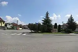 Centre of Římov | |
 Flag  Coat of arms | |
 Římov Location in the Czech Republic | |
| Coordinates: 49°10′12″N 15°45′28″E / 49.17000°N 15.75778°E | |
| Country | |
| Region | Vysočina |
| District | Třebíč |
| First mentioned | 1257 |
| Area | |
| • Total | 9.16 km2 (3.54 sq mi) |
| Elevation | 506 m (1,660 ft) |
| Population (2023-01-01)[1] | |
| • Total | 429 |
| • Density | 47/km2 (120/sq mi) |
| Time zone | UTC+1 (CET) |
| • Summer (DST) | UTC+2 (CEST) |
| Postal code | 675 22 |
| Website | www |
Římov is a municipality and village in Třebíč District in the Vysočina Region of the Czech Republic. It has about 400 inhabitants.
Římov lies approximately 11 kilometres (7 mi) south-west of Třebíč, 28 km (17 mi) south-east of Jihlava, and 141 km (88 mi) south-east of Prague.
Administrative parts
Villages and hamlets of Branišovice, Dolní Stropnice, Dolní Vesce, Horní Vesce and Kladiny are administrative parts of Římov.
References
Wikimedia Commons has media related to Římov (Třebíč District).
This article is issued from Wikipedia. The text is licensed under Creative Commons - Attribution - Sharealike. Additional terms may apply for the media files.