Žiželice | |
|---|---|
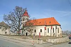 Church of Saint Procopius with a protected small-leaved linden | |
 Žiželice Location in the Czech Republic | |
| Coordinates: 50°7′55″N 15°23′36″E / 50.13194°N 15.39333°E | |
| Country | |
| Region | Central Bohemian |
| District | Kolín |
| First mentioned | 1052 |
| Area | |
| • Total | 18.61 km2 (7.19 sq mi) |
| Elevation | 211 m (692 ft) |
| Population (2023-01-01)[1] | |
| • Total | 1,786 |
| • Density | 96/km2 (250/sq mi) |
| Time zone | UTC+1 (CET) |
| • Summer (DST) | UTC+2 (CEST) |
| Postal codes | 281 26, 281 29 |
| Website | www |
Žiželice is a municipality and village in Kolín District in the Central Bohemian Region of the Czech Republic. It has about 1,800 inhabitants.
Administrative parts
Villages of Hradišťko II, Končice, Kundratice, Loukonosy, Pod Vinicí and Zbraň are administrative parts of Žiželice.
Geography
Žiželice is located about 17 kilometres (11 mi) northeast of Kolín and 28 km (17 mi) northwest of Pardubice. It lies in a flat and mostly agricultural landscape in the Central Elbe Table. The highest point is at 248 m (814 ft) above sea level. The Cidlina River flows through the municipality.
History
The first written mention of Žiželice is from 1052, when there was already a church and the village served as a market centre. In 1321, the then owner of Žiželice, Lord Dětoch, founded a new village called Žiželice next to the old village and renamed the old village Končice. From the 14th century, the estate was owned by the Rosenberg family. Peter I of Rosenberg had demolished the old wooden church in 1347 and had built a new one. During the Hussite Wars in 1425, the village was burned down, but soon was restored. At the end of the Thirty Years' War, Žiželice was again burned down.[2]
In the 19th century, the railway was built and Žiželice was industrialized. There used to be a sugar factory and a textile factory.[2]
Demographics
|
|
| ||||||||||||||||||||||||||||||||||||||||||||||||||||||
| Source: Censuses[3][4] | ||||||||||||||||||||||||||||||||||||||||||||||||||||||||
Transport
The D11 motorway (part of the European route E67) from Prague to Hradec Králové passes through the municipality.
Sights
The landmark of Žiželice is the Church of Saint Procopius. It was built in the Gothic style after 1347 and modified in 1712. After being damaged by a fire in 1830, the church was reconstructed and its early Baroque equipment was replaced with a new one.[5]
References
- ↑ "Population of Municipalities – 1 January 2023". Czech Statistical Office. 2023-05-23.
- 1 2 "Historie" (in Czech). Obec Žiželice. Retrieved 2023-03-23.
- ↑ "Historický lexikon obcí České republiky 1869–2011 – Okres Kolín" (in Czech). Czech Statistical Office. 2015-12-21. pp. 13–14.
- ↑ "Population Census 2021: Population by sex". Public Database. Czech Statistical Office. 2021-03-27.
- ↑ "Kostel sv. Prokopa". Cesty a památky (in Czech). Retrieved 2023-03-23.