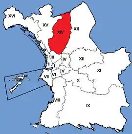
14th arrondissement of Marseille | |
|---|---|
 Location within Marseille | |
| Coordinates: 43°20′33″N 5°23′19″E / 43.3426°N 5.3887°E | |
| Country | France |
| Region | Provence-Alpes-Côte d'Azur |
| Department | Bouches-du-Rhône |
| Commune | Marseille |
| Government | |
| • Mayor (2020–2026) | Marion Bareille (LR) |
| Area | 16.39 km2 (6.33 sq mi) |
| Population | 60,968 |
| • Density | 3,720/km2 (9,600/sq mi) |
| INSEE code | 13214 |
The 14th arrondissement of Marseille is one of the 16 arrondissements of Marseille. It is governed locally together with the 13th arrondissement, with which it forms the 7th sector of Marseille.
Population
| Neighbourhood | population 1990 | population 1999 | population 2006 |
|---|---|---|---|
| Les Arnavaux | 6 341 | 6 340 | 6 004 |
| Bon-Secours | 11 133 | 11 116 | 11 672 |
| Le Canet | 7 276 | 7 311 | 8 737 |
| Le Merlan | 8 342 | 8 439 | 8 765 |
| Saint-Barthélémy | 16 559 | 15 920 | 17 831 |
| Saint-Joseph | 5 030 | 5 095 | 5 149 |
| Sainte-Marthe | 2 316 | 2 534 | 3 161 |
| Total | 56 997 | 56 755 | 61 317 |
Education
The private Catholic school École Tour-Sainte is in the 14th arrondissement.[2]
Demographics
Euronews claimed in August 2021 that the 14th arrondissement is "one of the city's most deprived".[3]
References
- ↑ "Populations légales 2020". The National Institute of Statistics and Economic Studies. 29 December 2022.
- ↑ Bonnafoy, Coralie (2015-04-27). ""Dieu est dans l'école, même si ce n'est pas mon dieu"". Libération. Retrieved 2018-05-31.
- ↑ "Teenager shot dead and two others injured on Marseille housing estate". Euronews. 2021-08-19.
External links
- Official website
- Dossier complet, INSEE
This article is issued from Wikipedia. The text is licensed under Creative Commons - Attribution - Sharealike. Additional terms may apply for the media files.