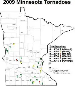
The following is a list of 2009 Minnesota tornadoes. Minnesota is a state located in the North Central United States along the northern edge of Tornado Alley, and on average receives 24 tornadoes per year. 2009 was an average year historically, with 24 confirmed tornado touchdowns. Twenty-two of the tornadoes (91%) were considered minor, rated EF0 or EF1 on the Enhanced Fujita scale. The remaining two tornadoes were rated as significant, at EF2.[1]
The 24 tornadoes combined to cause $4.5 million in damage, and they did not cause any fatalities or injuries. The date range of the tornadoes was smaller than normal, lasting just over two months, from just June 17–August 19. The first tornado date of June 17 marked the third-latest-starting tornado season on record in Minnesota since 1950, behind only 1951 (June 19) and 1952 (June 23).[2]
The most unusual tornado event of the year occurred on August 19. Seven tornadoes were recorded in Minnesota that day, including one that touched down in Minneapolis. What made this day unusual is that a unique atmospheric setup allowed several of the tornadoes to be spawned from rain showers where no lightning was present.[3][4]
Tornado descriptions
| EFU | EF0 | EF1 | EF2 | EF3 | EF4 | EF5 | Total |
|---|---|---|---|---|---|---|---|
| 0 | 16 | 6 | 2 | 0 | 0 | 0 | 24 |
June
June 17
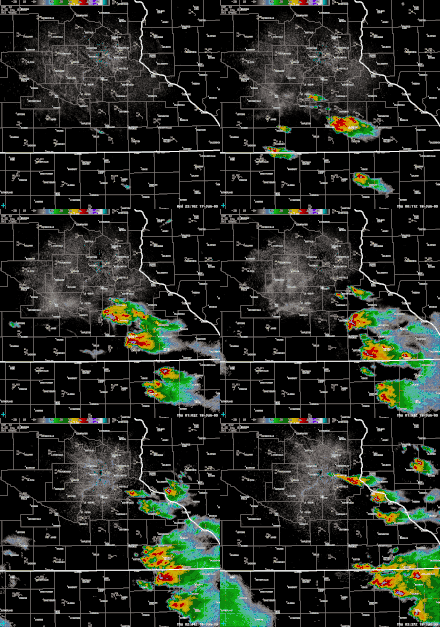
A weak area of surface low pressure moved into extreme southeast North Dakota late on the afternoon of the June 17, with a warm front stretching across southeastern Minnesota.[5] The warm front combined with pre-existing moisture from morning rainfall which led to rapid destabilization of the atmosphere during the afternoon hours. To the east of the low pressure area, surface dew point values rose into the middle 60s °F (18 °C) with temperatures near 80 °F (27 °C), causing a very unstable air mass to develop.
Two tornadoes were reported in west-central Minnesota in Wilkin County.[6] Other, strong thunderstorms developed later just south of the warm front near Albert Lea and moved northeast. The thunderstorms quickly became tornadic north of Albert Lea, near Geneva, where a touchdown was observed. There were several reports of funnel clouds throughout the early evening with one more official touchdown near Waseca. The storms later turned to the southeast and impacted the Austin area, causing serious damage.[7]
| List of confirmed tornadoes (6) – Wednesday, June 17, 2009 | ||||||
|---|---|---|---|---|---|---|
| EF# | Location | County | Coord. | Time (UTC) | Path length | Description/Damage |
| EF0 | SSW of Doran | Wilkin | 46°05′N 96°17′W / 46.09°N 96.29°W | 2140 | .1 miles (0.16 km) | A brief tornado touchdown in an open field just east of U.S. Route 75 was reported. Peak winds were estimated at 80 miles per hour (129 km/h).[6] |
| EF0 | E of Tenney | Wilkin | 46°01′N 96°14′W / 46.02°N 96.23°W | 2208 | 1 mile (1.6 km) | A brief tornado touchdown was reported near the Wilkin and Traverse County line. The tornado tracked for roughly a mile across open fields. Peak winds were estimated at 80 miles per hour (129 km/h).[8] |
| EF0 | SSW of Geneva | Freeborn | 43°29′N 93°09′W / 43.49°N 93.15°W | 0030 | 1.8 miles (2.9 km) | Several trees and two sheds were damaged on the northeast corner of Interstate 35 and County Road 35, on the west edge of Geneva. There was minor tree damage associated with the tornado on the east side of Geneva, with the last damage just south of the intersection of County Roads 26 and 35. The tornado caused $1000 in damage.[9] |
| EF2 | Austin | Mower | 43°26′N 93°01′W / 43.43°N 93.01°W | 0100 | 9.6 miles (15.4 km) |  Tornado damage in Austin, Minnesota. |
| EF0 | Adams | Mower | 43°20′N 92°26′W / 43.34°N 92.43°W | 0151 | .1 miles (0.16 km) | A brief tornado was witnessed by storm spotters.[10] |
| EF0 | E of Waseca | Waseca | 44°02′N 93°16′W / 44.04°N 93.26°W | 0102 | 2.3 miles (3.7 km) | A tornado was observed forming just north of the City of Waseca on Clear Lake. The tornado moved onshore and then eastsouthward to Goose Lake. No property damage occurred but several large 14 inches (36 cm) diameter trees were uprooted when the tornado came onshore. Other broken trees were noted near Goose Lake.[5] |
June 18
Moisture levels were high on June 18, with surface dew points in the middle 60s °F (18 °C). Some morning cloud cover along the North Dakota/South Dakota border lifted north by afternoon which allowed a period of heating. Although the upper-level winds were fairly light, another in a series of upper-level disturbances shifted over this region by mid-afternoon. This helped initiate thunderstorm development over southeast North Dakota and west central Minnesota, leading to two tornadoes near Carlisle and Dent.
| List of confirmed tornadoes (2) – Thursday, June 18, 2009 | ||||||
|---|---|---|---|---|---|---|
| EF# | Location | County | Coord. | Time (UTC) | Path length | Description/Damage |
| EF0 | NW of Carlisle | Otter Tail | 46°14′N 96°05′W / 46.23°N 96.08°W | 2350 | 3 miles (4.8 km) | Peak winds were estimated at 80 miles per hour (129 km/h).[11] |
| EF1 | NW of Dent | Otter Tail | 46°20′N 95°26′W / 46.33°N 95.43°W | 0015 | 1 mile (1.6 km) | A tornado touched down briefly near Dent, knocking down several large trees and ripping the roof off the dugout at the baseball field. The tornado tracked for about 1 mile (1.6 km) and peak winds were estimated at 90 miles per hour (145 km/h).[12] |
June 21
During the late afternoon a very warm and humid air mass lifted northward across northern Iowa and into far southern Minnesota. Several weak storms formed in northwest and north central Iowa and moved into south central Minnesota where a warm front laid. Winds shifted from the south to the east and southeast across Freeborn and Faribault counties of far south central Minnesota. The combination of increasing wind shear near the boundary layer and enough lift from thunderstorms allowed brief tornadoes to develop.
| List of confirmed tornadoes (4) – Sunday, June 21, 2009 | ||||||
|---|---|---|---|---|---|---|
| EF# | Location | County | Coord. | Time (UTC) | Path length | Description/Damage |
| EF0 | NE of Easton | Faribault | 43°28′N 93°32′W / 43.47°N 93.54°W | 0036 | .1 miles (0.16 km) | Tree and garage damaged from brief touchdown at a farmstead. It caused $1,000 in damage.[13] |
| EF0 | W of Walters | Faribault | 43°22′N 93°25′W / 43.36°N 93.42°W | 0108 | .3 miles (0.48 km) | Tornado moved through a field, blew the lids off the top of two grain bins, then crossed Highway 22 and dissipated in a corn field. It caused $1,000 in damage.[14] |
| EF0 | NE of Walters | Faribault | 43°22′N 93°23′W / 43.37°N 93.39°W | 0118 | .1 miles (0.16 km) | Brief touchdown in open field.[15] |
| EF1 | W of Alden | Freeborn | 43°23′N 93°22′W / 43.39°N 93.37°W | 0132 | 1.8 miles (2.9 km) | Tornado touched down briefly at 7:32 pm CST in an open field, then lifted up, and touched down again at 1935 CST. It moved across a corn field and into a farmstead, knocking down several trees and blowing away a garden bench. The tornado continued moving north into another corn field, where it dissipated.[16] |
July
July 7
Thunderstorms produced damaging winds, hail, and one tornado in Murray and Cottonwood Counties in southwest Minnesota on the late afternoon of July 7.
| List of confirmed tornadoes (1) – Tuesday, July 7, 2009 | ||||||
|---|---|---|---|---|---|---|
| EF# | Location | County | Coord. | Time (UTC) | Path length | Description/Damage |
| EF0 | N of Storden | Cottonwood | 44°04′N 95°11′W / 44.07°N 95.19°W | 2310 | .2 miles (0.32 km) | A brief tornado with no reported damage.[17] |
July 14
A strong cold front, deep moisture and a high wind shear environment led to severe weather across portions of central Minnesota during the late-afternoon hours. Several individual storms developed across west central Minnesota and moved quickly northeast; spawning three tornadoes.
| List of confirmed tornadoes (3) – Tuesday, July 14, 2009 | ||||||
|---|---|---|---|---|---|---|
| EF# | Location | County | Coord. | Time (UTC) | Path length | Description/Damage |
| EF2 | Swift Falls | Swift and Pope | 45°14′N 95°14′W / 45.24°N 95.24°W | 2121 | 7.9 miles (12.7 km) | A tornado moved through portions of Swift and Pope Counties in west central Minnesota where two turkey barns and several outbuildings were destroyed, with extensive tree damage throughout the entire path. Maximum damage was EF-2 with estimated winds of 111 miles per hour (179 km/h) – 119 miles per hour (192 km/h). In the town of Swift Falls, two residences were damaged along with two garages that were destroyed. The tornado produced minor crop damage northeast of Swift Falls. In all this tornado produced approximately $510,000 in damage.[18] |
| EF1 | Spicer | Kandiyohi | 45°07′N 94°35′W / 45.12°N 94.58°W | 2141 | 6.4 miles (10.3 km) | 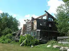 A home damaged near Spicer. A tornado moved through portions of Kandiyohi County near the town of Spicer. Portions of downtown Spicer were damaged including the partial destruction of the upper level of a home, there was roof damage to multiple houses, several outbuildings were destroyed, and a dozen or more car windows blown out at the local Green Mall parking lot. Maximum winds were estimated between 100 miles per hour (161 km/h) to 110 miles per hour (177 km/h) and $250,000 in damage was reported.[19] |
| EF0 | NW of Elrosa | Stearns | 45°20′N 94°35′W / 45.34°N 94.59°W | 2207 | .1 miles (0.16 km) | Brief touchdown in an open field – no damage.[20] |
August
August 8
A very unstable air mass was in place across the upper Midwest with a warm front draped from the Twin Cities area into west-central Wisconsin. A strong capping inversion suppressed thunderstorm development until near sunset, when a supercell thunderstorm developed in the western part of Hennepin County ahead of an advancing cold front near a surface low pressure center. The supercell would produce a tornado in Hennepin county before tracking eastward across the northern Twin Cities metro area and into Wisconsin where it produced two more tornadoes.
| List of confirmed tornadoes (1) – Tuesday, August 8, 2009 | ||||||
|---|---|---|---|---|---|---|
| EF# | Location | County | Coord. | Time (UTC) | Path length | Description/Damage |
| EF1 | Minnetrista, Orono, Long Lake, Plymouth | Hennepin | 44°34′N 93°24′W / 44.57°N 93.40°W | 0023 | 9.1 miles (14.6 km) | 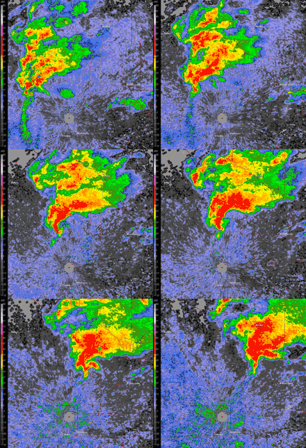 Radar loop of the tornado-producing supercell over Hennepin County. |
August 19
Low pressure was moving into Minnesota from the west-southwest on Wednesday, August 19, causing a large area of shower activity to shroud east-central and south-central Minnesota during the morning and early-afternoon hours. The low began to deepen rapidly in the late morning and early afternoon as it moved northeast over the Twin Cities metro area.
Embedded circulations began to develop within the shower activity by 2:00 pm CDT, when the deepening low started to produce strong atmospheric wind speeds which were turning in the lower portion of the atmosphere. These circulations were moving quickly to the north and many were not associated with thunderstorms; there were only a handful of cloud-to-ground lightning strikes all afternoon in the areas where damage was reported.
While there was relatively little instability, there was enough rising air and surface inflow to stretch these circulations at times and form short-lived tornadoes.[23][24]
| List of confirmed tornadoes (7) – Tuesday, August 19, 2009 | ||||||
|---|---|---|---|---|---|---|
| EF# | Location | County | Coord. | Time (UTC) | Path length | Description/Damage |
| EF0 | Minneapolis | Hennepin | 44°32′N 93°09′W / 44.54°N 93.15°W | 1850 | 4.3 miles (6.9 km) |  Damage to homes in South Minneapolis |
| EF1 | SE of New Trier | Dakota | 44°20′N 92°32′W / 44.34°N 92.54°W | 1916 | 1.6 miles (2.6 km) | A roof was completely torn off a farm house, and several large sheds and outbuildings were destroyed. The tornado tracked through corn fields, from south-southeast to the north-northwest and caused $75,000 in damage to property and crops.[25] |
| EF1 | Cottage Grove | Washington | 44°28′N 92°31′W / 44.46°N 92.51°W | 1940 | .7 miles (1.1 km) | An EF-1 tornado tracked from near U.S. Route 61 and 122nd Street South, to near Lehigh Avenue South on the far southeast periphery of Cottage Grove. The majority of the damage occurred in the 11700 block of Lockridge Avenue. This is where the tornado was rated an EF-1 based on large trees uprooted and winds estimated near 90 miles per hour (145 km/h). Other structural damage in the residential area included a garage door collapsed inward, wooden fences were blown down, and a metal shed blew across the street.[26] |
| EF0 | Ham Lake | Anoka | 45°09′N 93°07′W / 45.15°N 93.12°W | 2007 | .1 miles (0.16 km) | Brief tornado touchdown in an unpopulated section of Ham Lake.[27] |
| EF0 | Marine on St. Croix | Washington | 45°07′N 92°28′W / 45.12°N 92.46°W | 2025 | .7 miles (1.1 km) | Scattered trees and large limbs were downed as a tornado moved from southeast to northwest across western sections of Marine on St. Croix.[28] |
| EF0 | North Branch | Chisago | 45°19′N 92°35′W / 45.31°N 92.58°W | 2100 | .9 miles (1.4 km) | An EF-0 tornado tracked from near the North Branch Middle School, northwest to near Rivercrest and Riverview Courts in North Branch, Minnesota. Roof damage was indicated at the middle school, with a telephone pole snapped, and major trees blown down in the residential area. Based on roof damage and trees blown down, winds were estimated at 70 miles per hour (113 km/h) to 80 miles per hour (129 km/h).[29] |
| EF0 | SE of Springfield | Brown | 44°08′N 94°31′W / 44.13°N 94.51°W | 2328 | 3.7 miles (6.0 km) | Occasional brief tornado touchdowns between Springfield and Leavenworth, Minnesota for approximately 15 minutes produced $25,000 in crop damage.[30] |
See also
References
- ↑ "2009 Minnesota tornadoes". National Weather Service. 2009. Archived from the original on 8 January 2010. Retrieved 2010-02-09.
- ↑ "June 17, 2009: Tornadoes in Southern Minnesota". National Weather Service. July 18, 2009. Retrieved 2010-02-09.
- ↑ "Wednesday tornadoes: Oddball weather event". Minnesota Public Radio. August 20, 2009. Retrieved 2010-02-09.
- ↑ "Heavy Rain and Tornadoes August 19, 2009". University of Minnesota. August 20, 2009. Retrieved 2010-02-09.
- 1 2 "Event Record Details - 17 June 2009". National Climatic Data Center. June 17, 2009. Retrieved 2010-02-09.
- 1 2 "Event Record Details - 17 June 2009". National Climatic Data Center. June 17, 2009. Retrieved 2010-02-09.
- 1 2 "Event Record Details - 17 June 2009". National Climatic Data Center. June 17, 2009. Retrieved 2010-02-09.
- ↑ "Event Record Details - 17 June 2009". National Climatic Data Center. June 17, 2009. Retrieved 2010-02-09.
- ↑ "Event Record Details - 17 June 2009". National Climatic Data Center. June 17, 2009. Retrieved 2010-02-09.
- ↑ "Event Record Details - 17 June 2009". National Climatic Data Center. June 17, 2009. Retrieved 2010-02-09.
- ↑ "Event Record Details - 18 June 2009". National Climatic Data Center. June 18, 2009. Retrieved 2010-02-09.
- ↑ "Event Record Details - 18 June 2009". National Climatic Data Center. June 18, 2009. Retrieved 2010-02-09.
- ↑ "Event Record Details - 21 June 2009". National Climatic Data Center. June 21, 2009. Retrieved 2010-02-10.
- ↑ "Event Record Details - 21 June 2009". National Climatic Data Center. June 21, 2009. Retrieved 2010-02-10.
- ↑ "Event Record Details - 21 June 2009". National Climatic Data Center. June 21, 2009. Retrieved 2010-02-10.
- ↑ "Event Record Details - 21 June 2009". National Climatic Data Center. June 21, 2009. Retrieved 2010-02-10.
- ↑ "Event Record Details - 7 July 2009". National Climatic Data Center. July 7, 2009. Retrieved 2010-02-10.
- ↑ "Event Record Details - 14 July 2009". National Climatic Data Center. July 14, 2009. Retrieved 2010-02-10.
- ↑ "Event Record Details - 14 July 2009". National Climatic Data Center. July 14, 2009. Retrieved 2010-02-10.
- ↑ "Event Record Details - 21 June 2009". National Climatic Data Center. July 14, 2009. Retrieved 2010-07-14.
- ↑ "Event Record Details - 8 August 2009". National Climatic Data Center. August 8, 2009. Retrieved 2010-02-10.
- ↑ "August 8, 2009: Tornado in the Western Twin Cities and Two More in Western Wisconsin". National Weather Service. August 15, 2009. Retrieved 2010-02-10.
- 1 2 "August 19, 2009: Multiple Tornadoes Across the Area, Including in Minneapolis". National Weather Service. September 2, 2009. Retrieved 2010-02-10.
- 1 2 "Event Record Details - 19 August 2009". National Climatic Data Center. August 19, 2009. Retrieved 2010-02-10.
- ↑ "Event Record Details - 19 August 2009". National Climatic Data Center. August 19, 2009. Retrieved 2010-02-10.
- ↑ "Event Record Details - 19 August 2009". National Climatic Data Center. August 19, 2009. Retrieved 2010-02-10.
- ↑ "Event Record Details - 19 August 2009". National Climatic Data Center. August 19, 2009. Retrieved 2010-02-10.
- ↑ "Event Record Details - 19 August 2009". National Climatic Data Center. August 19, 2009. Retrieved 2010-02-10.
- ↑ "Event Record Details - 19 August 2009". National Climatic Data Center. August 19, 2009. Retrieved 2010-02-10.
- ↑ "Event Record Details - 19 August 2009". National Climatic Data Center. August 19, 2009. Retrieved 2010-02-10.