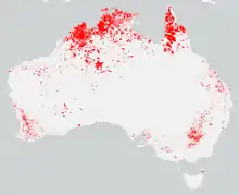
 | |
| Location | Australia |
|---|---|
| Statistics | |
| Date(s) | June 2016 – June 2017 |
| Season | |
The summer of 2016–17 saw a very wet start with the fifth-wettest December[1] on record being 76 percent above the average rainfall for the month across much of the country. This caused a significant surge in vegetation growth leading into the fire danger period.
Significant fires
| State | Start date | Deaths | Injuries | Res. houses lost | Other structures lost | Area (ha) | Local govt. | Impacted communities | Duration | Ref. |
|---|---|---|---|---|---|---|---|---|---|---|
| NSW | 11 February 2017 | 35 | 52,000+ ha | Warrumbungle | Uarbry | 3 days | [2] | |||
| NSW | 17 February 2017 | 0 | 0 | 11 destroyed; 12 damaged. | 3,500 ha | Carwoola, Captains Flat | 2 days | [3] | ||
| WA | 26 January 2017 | 0 | 0 | 0 | 2 | Capel | Gwindinup Argyle | |||
| WA | 21 December 2016 | 2,000 ha | Gingin Dandaragen | Mimegarra
Cataby Regans Ford Red Gully |
||||||
| NSW | 6,500 | Port Stephens | Port Stephens | [4] | ||||||
| VIC | 5 Jan 2017 | 150 | Kellalac | [5] | ||||||
| VIC | 24 Dec 2016 | 150 | Bridgewater | |||||||
| ACT | 24 Jan 2017 | 2,450 | Tarago | [6] |
See also
References
- ↑ "Australia in December 2016". www.bom.gov.au. Retrieved 2017-01-28.
- ↑ "35 homes razed in NSW blazes: RFS". SBS News. SBS. 15 February 2017. Retrieved 15 February 2017.
- ↑ Le Lievre, Kimberley; Groch, Sherryn; Brown, Andrew (18 February 2017). "Police investigate blaze near Queanbeyan as fire crews battle on". The Canberra Times. Retrieved 21 February 2017.
- ↑ "Crews battle bushfires at Hunter's Port Stephens, Cessnock". ABC New. 2016-11-06. Retrieved 2017-01-28.
- ↑ Media, CFA. "Grassfire in Kellalac - CFA". CFA. Archived from the original on 2017-02-16. Retrieved 2017-01-28.
- ↑ Cootes, Georgina Mitchell, Charli Shield, Isobel (2017-01-29). "One home destroyed in Currandooley bushfire". The Wimmera Mail-Times. Retrieved 2017-01-29.
{{cite news}}: CS1 maint: multiple names: authors list (link)
This article is issued from Wikipedia. The text is licensed under Creative Commons - Attribution - Sharealike. Additional terms may apply for the media files.