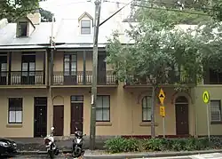
| 52–54 Kent Street, Millers Point | |
|---|---|
 52–54 Kent Street, Millers Point, NSW | |
| Location | 52, 54 Kent Street, Millers Point, City of Sydney, New South Wales, Australia |
| Coordinates | 33°51′35″S 151°12′14″E / 33.8596°S 151.2039°E |
| Architectural style(s) | Victorian Filigree |
| Official name | Terrace |
| Type | State heritage (built) |
| Designated | 2 April 1999 |
| Reference no. | 871 |
| Type | Terrace |
| Category | Residential buildings (private) |
 Location of 52–54 Kent Street, Millers Point in Sydney | |
52–54 Kent Street, Millers Point are heritage-listed terrace houses located at 52–54 Kent Street, in the inner city Sydney suburb of Millers Point in the City of Sydney local government area of New South Wales, Australia. The property was added to the New South Wales State Heritage Register on 2 April 1999.[1]
History
Millers Point is one of the earliest areas of European settlement in Australia, and a focus for maritime activities. Terrace housing built during the 1860s. First tenanted by the NSW Department of Housing in 1982.[1]
Description
A simple well proportioned two storey Victorian terrace house with two bedrooms. Features include a cantilevered balcony over footpath, a corrugated iron verandah painted in wide stripes, two french doors with fanlights on upper storey, panelled front door with fanlight and single window with slab sill on ground floor. Also, a second doorway on ground floor, perhaps leading to rear yard, and dormer window to attic room. Storeys: Two; Construction: Painted rendered masonry. Corrugated galvanised iron roof. Timber balcony structure and column supports for verandah roof. Iron lace balustrading. Style: Victorian Filigree.[1]
The external condition of the property is good.
Modifications and dates
External: Doors replaced. Some iron railing removed. Last inspected: 19 February 1995.[1]
Heritage listing
As at 23 November 2000, this 1860s terrace forms part of a cohesive streetscape element.[1]
It is part of the Millers Point Conservation Area, an intact residential and maritime precinct. It contains residential buildings and civic spaces dating from the 1830s and is an important example of 19th century adaptation of the landscape.[1]
52–54 Kent Street, Millers Point was listed on the New South Wales State Heritage Register on 2 April 1999.[1]
See also
References
Bibliography
- Brooks & Associates (1998). Department of Housing s170 Register.
- NBRS+Partners (2017). 52 Kent Street, Millers Point - Conservation Management Plan.
- URBIS (2015). 54A and 54B Kent Street, Millers Point.
Attribution
![]() This Wikipedia article was originally based on Terrace, entry number 871 in the New South Wales State Heritage Register published by the State of New South Wales (Department of Planning and Environment) 2018 under CC-BY 4.0 licence, accessed on {{{accessdate}}}.
This Wikipedia article was originally based on Terrace, entry number 871 in the New South Wales State Heritage Register published by the State of New South Wales (Department of Planning and Environment) 2018 under CC-BY 4.0 licence, accessed on {{{accessdate}}}.
External links
- Paul Davies Pty Ltd (March 2007). "Millers Point and Walsh Bay Heritage Review" (PDF). City of Sydney.