Kamchatka Krai was formed on July 1, 2007 as a result of the merger of Kamchatka Oblast with Koryak Autonomous Okrug.
| Kamchatka Krai, Russia | |
|---|---|
| Administrative center: Petropavlovsk-Kamchatsky | |
| As of 2014:[1] | |
| # of districts (районы) | 11 |
| # of cities/towns (города) | 3 |
| # of urban-type settlements (посёлки городского типа) | 2 |
| As of 2002:[2] | |
| # of rural localities (сельские населённые пункты) | 83 |
| # of uninhabited rural localities (сельские населённые пункты без населения) | 10 |

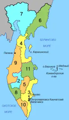
Map of Kamchatka Krai
Administrative and municipal divisions
- ✪ - part of Koryak Okrug (Корякия о́круг)
| Number on map | Division | Structure | OKATO | OKTMO | Urban-type settlement | ||
|---|---|---|---|---|---|---|---|
| Administrative | Municipal | ||||||
| - | Vilyuchinsk (Вилючинск) | city (ZATO) | urban okrug | 30 535 | 30 735 | ||
| - | Petropavlovsk-Kamchatsky (Петропавловск-Камчатский) | city | urban okrug | 30 401 | 30 701 | ||
| - | Yelizovo (Елизово) | city | (under Yelizovsky) | 30 402 | 30 607 | ||
| 1 | Aleutsky (Алеутский) | district | 30 201 | 30 601 | |||
| 2 | Bystrinsky (Быстринский) | district | 30 204 | 30 604 | |||
| 3 | Yelizovsky (Елизовский) | district | 30 207 | 30 607 |
| ||
| 5 | Milkovsky (Мильковский) | district | 30 210 | 30 610 | |||
| 8 | Sobolevsky (Соболевский) | district | 30 213 | 30 613 | |||
| 10 | Ust-Bolsheretsky (Усть-Большерецкий) | district | 30 216 | 30 616 | |||
| 11 | Ust-Kamchatsky (Усть-Камчатский) | district | 30 219 | 30 619 | |||
| 4 | ✪ | Karaginsky (Карагинский) | special district | district | 30 124 | 30 824 | |
| 6 | ✪ | Olyutorsky (Олюторский) | special district | district | 30 127 | 30 827 | |
| 7 | ✪ | Penzhinsky (Пенжинский) | special district | district | 30 129 | 30 829 | |
| 9 | ✪ | Tigilsky (Тигильский) | special district | district | 30 132 | 30 832 | |
| - | ✪ | Palana (Палана) | (under Tigilsky) | urban okrug | 30 132 | 30 851 | |
See also
References
- ↑ Государственный комитет Российской Федерации по статистике. Комитет Российской Федерации по стандартизации, метрологии и сертификации. №ОК 019-95 1 января 1997 г. «Общероссийский классификатор объектов административно-территориального деления. Код 30», в ред. изменения №278/2015 от 1 января 2016 г.. (State Statistics Committee of the Russian Federation. Committee of the Russian Federation on Standardization, Metrology, and Certification. #OK 019-95 January 1, 1997 Russian Classification of Objects of Administrative Division (OKATO). Code 30, as amended by the Amendment #278/2015 of January 1, 2016. ).
- ↑ Results of the 2002 Russian Population Census—Territory, number of districts, inhabited localities, and rural administrations of the Russian Federation by federal subject Archived September 28, 2011, at the Wayback Machine
This article is issued from Wikipedia. The text is licensed under Creative Commons - Attribution - Sharealike. Additional terms may apply for the media files.