Aeroflex–Andover Airport | |||||||||||
|---|---|---|---|---|---|---|---|---|---|---|---|
 | |||||||||||
| Summary | |||||||||||
| Airport type | Public use | ||||||||||
| Owner | New Jersey Forest Fire Service | ||||||||||
| Operator | John T. Flyntz | ||||||||||
| Serves | Andover, New Jersey | ||||||||||
| Location | Sussex County, New Jersey | ||||||||||
| Elevation AMSL | 583 ft / 178 m | ||||||||||
| Coordinates | 41°00′31.031″N 074°44′16.922″W / 41.00861972°N 74.73803389°W | ||||||||||
| Website | New Jersey State Forest Fire Service | ||||||||||
| Runways | |||||||||||
| |||||||||||
| Statistics (2010) | |||||||||||
| |||||||||||
Aeroflex–Andover Airport (FAA LID: 12N) is a public-use airport located two nautical miles (3.704 km) north of Andover within Kittatinny Valley State Park in Sussex County, New Jersey, United States.[2][3][4] The airport is publicly owned by the New Jersey Forest Fire Service[1] and used as a base for aerial wildfire suppression.
Facilities and aircraft
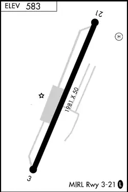
Aeroflex–Andover Airport covers an area of 12 acres (4.9 ha) at an elevation of 583 feet (178 m) above mean sea level. It has one runway designated 03/21 with an asphalt surface measuring 1,981 by 50 feet (604 x 15 m).[1]
For the 12-month period ending January 1, 2010, the airport had 24,826 aircraft operations, an average of 68 per day: 100% general aviation. At that time there were 48 aircraft based at this airport: 98% single-engine and 2% helicopter.[1]
Runway issues
Pilots consider landing on the short runway challenging, particularly for those who do not regularly use the airport. With large lakes on either end, it has been likened to an aircraft carrier.[5] While Flying editor Stephen Pope, who lives in northern New Jersey, considers that reputation to be exaggerated, "it wouldn't be my first choice if I had to divert with my family on board."[6]
| External videos | |
|---|---|
Pope was referring to one of two recent incidents where landing planes had come in too fast and gone off the runway into the water. In that July 5, 2019, accident, the pilot of a Cessna C172 who had left Harrisburg, Pennsylvania, with his wife and children aboard was forced to divert when Morristown Municipal Airport, his intended destination, was temporarily closed so that President Donald Trump and his wife could go to the resort he owns in nearby Bedminster and play golf. The pilot and his family were rescued by a nearby fisherman before their plane could sink in 18–24 feet (5.5–7.3 m) of water in 119-acre (48 ha) Lake Aeroflex north of the runway. None of them were injured.[7]
In the earlier incident, on April 23, 2018, the pilot of a single-engine Citabria was traveling faster when he landed the plane and thus went further into the lake, roughly 100 to 150 yards (91 to 137 m), according to observers. He was able to escape the aircraft before it sank at a point where the water was 80 feet (24 m) deep. After complaining of neck and chest pains, and having been exposed to cold water, he was airlifted to Morristown Memorial Hospital for treatment.[8]
See also
References
- 1 2 3 4 FAA Airport Form 5010 for 12N PDF, effective 2012-02-09
- ↑ Federal Aviation Administration, National Flight Data Center for Aeroflex–Andover Airport (12N). Retrieved July 18, 2015.
- ↑ "Aeroflex–Andover Airport – 12N". Aircraft Owners and Pilots Association. Retrieved 27 July 2015.
- ↑ Davisson, Budd (February 6, 2016). "Challenging Runways". Plane & Pilot. Retrieved August 21, 2019.
- ↑ Pope, Stephen. "Contingency Planning". Flying. p. 10.
- ↑ Comstock, Lori (July 5, 2019). "4 escape injury when aircraft goes off runway, submerges in Lake Aeroflex". New Jersey Herald. Retrieved August 21, 2019.
- ↑ Jennings, Rob (April 23, 2018). "Pilot injured when plane crashes into lake at N.J. airport". Newark Star-Ledger. Retrieved August 21, 2019.
External links
- FAA Terminal Procedures for 12N, effective December 28, 2023
- Resources for this airport:
- FAA airport information for 12N
- AirNav airport information for 12N
- FlightAware airport information and live flight tracker
- SkyVector aeronautical chart for 12N
- New Jersey Forest Fire Service