54°29′54″N 6°56′07″W / 54.498326°N 6.935376°W
Aghaginduff
| |
|---|---|
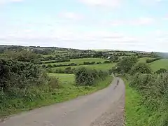 Aghaginduff townland in 2006 | |
| County | |
| Country | Northern Ireland |
| Sovereign state | United Kingdom |
| Postcode district | BT70 |
| Dialling code | 028 |
Aghaginduff (from Irish Achadh Cinn Duibh, meaning 'field of the black head')[1] is a townland in County Tyrone, Northern Ireland. It is situated in the historic barony of Dungannon Lower and the civil parish of Killeeshil and covers an area of 512 acres.[2] Aghaginduff is located approximately 12 km west of Dungannon, close to Cabragh.[3]
The townland contains St Joseph's Roman Catholic Church.
See also
References
- ↑ "Aghaginduff". Place Names NI. Retrieved 12 May 2015.
- ↑ "Aghaginduff". IreAtlas Townlands Database. Retrieved 12 May 2015.
- ↑ "Aghaginduff/Cabragh". Dungannon and South Tyrone Area Plan 2010. Planning Portal. Retrieved 12 May 2015.
Wikimedia Commons has media related to Aghaginduff.
This article is issued from Wikipedia. The text is licensed under Creative Commons - Attribution - Sharealike. Additional terms may apply for the media files.