Agwara
Kpacharka | |
|---|---|
LGA and town | |
| Nickname: AGR CITY | |
 Agwara Location in Nigeria | |
| Coordinates: 10°42′N 4°35′E / 10.700°N 4.583°E | |
| Country | |
| State | Niger State |
| Government | |
| • Local Government Chairman and the Head of the Local Government Council | Alh. Nura Mohammed |
| Area | |
| • Total | 1,538 km2 (594 sq mi) |
| Population (2006 census) | |
| • Total | 67,413 |
| Time zone | UTC+1 (WAT) |
| 3-digit postal code prefix | 923 |
| ISO 3166 code | NG.NI.AW |
Agwara (or Agwarra) is a Local Government Area in Niger State, Nigeria. Its headquarters are in the town of Agwara.
It has an area of 1,538 km2 and a population of 57,413 at the 2006 census.
The postal code of the area is 923.[1]
Climate
The climate is hot and oppressive, with a wet season that is overcast and partly cloudy, and a dry season that is partly cloudy.[2][3]
A daily maximum temperature of 97°F is typical during the 2.3-month hot season, which runs from February 24 to May 2. April has an average high temperature of 99°F and low temperature of 80°F, making it the hottest month of the year in Agwara.[4][2]
A daily high temperature below 88°F is typical during the 2.8-month cool season, which runs from July 3 to September 27. December, with an average low of 66°F and high of 90°F, is the coldest month of the year in Agwara.[2]
References
- ↑ "Post Offices- with map of LGA". NIPOST. Archived from the original on 7 October 2009. Retrieved 2009-10-20.
- 1 2 3 "Agwara Climate, Weather By Month, Average Temperature (Nigeria) - Weather Spark". weatherspark.com. Retrieved 2023-09-10.
- ↑ "Weather Archive Agwara". meteoblue. Retrieved 2023-09-10.
- ↑ "Monthly climate in Agwara, Niger, Nigeria". nomadseason.com. Retrieved 2023-09-27.
2.
By Bello Usman Gidi
By Lukman Umar Atako
State capital: Minna | ||
| Local Government Areas | 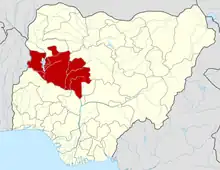 | |