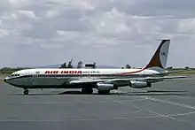
 The aircraft involved in the accident, 1976. | |
| Accident | |
|---|---|
| Date | 21 June 1982 |
| Summary | Pilot error; inclement weather as a contributing factor |
| Site | Sahar International Airport, Mumbai, India |
| Aircraft | |
| Aircraft type | Boeing 707–437 |
| Aircraft name | Gauri Shankar |
| Operator | Air India |
| Registration | VT-DJJ |
| Flight origin | Kuala Lumpur International Airport, Kuala Lumpur |
| Stopover | Madras International Airport, Madras (now Chennai) |
| Destination | Sahar International Airport, Bombay (now Mumbai) |
| Occupants | 111 |
| Passengers | 99 |
| Crew | 12 |
| Fatalities | 17 |
| Injuries | 25 |
| Survivors | 94 |
Air India Flight 403 was a scheduled Air India passenger flight that crashed at Sahar International Airport in Bombay, India on 21 June 1982. It was likely caused by miscalculated altitude in a heavy rainstorm. The aircraft was the first jetliner inducted into the fleet of an Asian airline.
Accident
On 21 June 1982, Air India Flight 403, a Boeing 707-437 (registered VT-DJJ) named Gauri Shankar, arriving from Kuala Lumpur International Airport via Madras (now Chennai), crashed after a hard landing during a rainstorm.[1] The fuselage exploded after starting a late go-around. Of 111 occupants on the aircraft, 2 of 12 crew members and 15 of 99 passengers were killed.[2][3]
Investigation
An Indian public inquiry determined the probable cause of the crash to be "Deliberate reduction of engine power by the pilot 12 seconds prior to first impact due to altitude unawareness resulting in a high rate of descent, very heavy landing and the undershooting of the aircraft by 1300 feet."[4]
References
- ↑ Mendis, Sean (26 July 2004). "Air India : The story of the aircraft". Airwhiners.net. Retrieved 13 June 2013.
- ↑ "Accident Database: Accident Synopsis 06221982". airdisaster.com. Archived from the original on 16 June 2008. Retrieved 25 May 2020.
{{cite web}}: CS1 maint: unfit URL (link) - ↑ "Air India plane crashes". www.airsafe.com. Retrieved 25 May 2020.
- ↑ Ranter, Harro. "ASN Aircraft accident Boeing 707-437 VT-DJJ Bombay-Santacruz Airport (BOM)". aviation-safety.net. Aviation Safety Network. Retrieved 25 May 2020.
19°05′20″N 72°52′12″E / 19.089°N 72.870°E