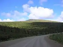
Steese Highway | ||||
|---|---|---|---|---|
| Alaska Route 6 Alaska Route 2 | ||||
Steese Highway highlighted in red | ||||
| Route information | ||||
| Length | 161 mi (259 km) | |||
| Existed | Late 1890s–present | |||
| Major junctions | ||||
| South end | ||||
| Chena Hot Springs Road near Fairbanks Circle Hot Springs Road in Central | ||||
| North end | River Street in Circle | |||
| Location | ||||
| Country | United States | |||
| State | Alaska | |||
| Highway system | ||||
| ||||
The Steese Highway (known as the Steese Expressway within Fairbanks) is a highway in the Interior region of the U.S. state of Alaska that extends 161 miles (259 km) from Fairbanks to Circle, a town on the Yukon River about 50 miles (80 km) south of the Arctic Circle.[1] The highway was completed in 1927 and is named for U.S. Army General James G. Steese, a former president of the Alaska Road Commission.[2] It is paved for about the first 81 miles (130 km) and around the town of Central it turns to dirt and gravel. Much of it is narrow and winding.
History
The highway and surrounding region has a long association with gold mining. It was built to service the Circle Mining District, which was very productive in the 1890s, before the discovery of gold in the Klondike. Both historic sites, such as Felix Pedro's 1902 gold discovery which resulted in the founding of Fairbanks, and the preserved gold camp at Chatanika, and active dredging operations line the road.

Route description
The Steese Highway is numbered Alaska Route 6 for most of its length, except for the first 11 miles (17 km) from Fairbanks to Fox, which are numbered Alaska Route 2. The highway has been designated as a National Scenic Byway.
There are three possible road closure barriers, so 511 Alaska should be checked before traveling its length to Circle Alaska.
Major Intersections
| Borough | Location | mi | km | Destinations | Notes |
|---|---|---|---|---|---|
| Fairbanks North Star | Fox | 0 | 0.0 | See Alaska Route 2#Major intersections for the junctions along the Alaska Route 2 section | |
| 11 | 18 | Alaska Route 2 continues north as the Elliot Highway and south as the remainder of the Steese Highway | |||
| Chatanika | 28 | 45 | Old Chatanika Highway | ||
| Unorganized | Central | 128 | 206 | Circle Hot Springs Road | |
| Circle | Road to Circle City Airport | ||||
| 161 | 259 | River Road | Northern terminus of Alaska Route 6 and the Steese Highway | ||
| 1.000 mi = 1.609 km; 1.000 km = 0.621 mi | |||||
References
- ↑ The Milepost 2009 edition, pages 506-512 ISBN 978-1-892154-26-2
- ↑ Steese, James Gordon (January 1914). "Transportation Conditions In Alaska". Review of Reviews. XLIX (1): 58–64. Retrieved 2009-08-14.

