Alberton, Alabama | |
|---|---|
 Alberton, Alabama  Alberton, Alabama | |
| Coordinates: 31°16′41″N 86°07′33″W / 31.27806°N 86.12583°W | |
| Country | United States |
| State | Alabama |
| County | Coffee |
| Elevation | 171 ft (52 m) |
| Time zone | UTC-6 (Central (CST)) |
| • Summer (DST) | UTC-5 (CDT) |
| Area code | 334 |
| GNIS feature ID | 112969[1] |
Alberton is an unincorporated community in Coffee County, Alabama, United States. Alberton is located along Alabama State Route 134, 9.7 miles (15.6 km) south-southwest of Elba.
History
A post office operated under the name Alberton from 1878 to 1904.[2]
Demographics
According to the returns from 1850[3]-2010[4] for Alabama, it has never reported a population figure separately on the U.S. Census.[5]
References
- ↑ "Alberton". Geographic Names Information System. United States Geological Survey, United States Department of the Interior.
- ↑ "Coffee County". Jim Forte Postal History. Retrieved January 3, 2016.
- ↑ http://www2.census.gov/prod2/decennial/documents/1850c-11.pdf, 1850 Census (places)
- ↑ http://www.census.gov/prod/cen2010/cph-1-2.pdf, 2010 AL Census
- ↑ "US Census Bureau Publications - Census of Population and Housing".
Municipalities and communities of Coffee County, Alabama, United States | ||
|---|---|---|
| Cities | 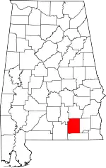 Map of Alabama highlighting Coffee County | |
| Towns | ||
| Unincorporated communities | ||
| Footnotes | ‡This populated place also has portions in an adjacent county or counties | |
This article is issued from Wikipedia. The text is licensed under Creative Commons - Attribution - Sharealike. Additional terms may apply for the media files.