Alto Gállego | |
|---|---|
.svg.png.webp) | |
| Country | |
| Autonomous community | Aragon |
| Province | Huesca |
| Capital | Sabiñánigo |
| Municipalities | |
| Area | |
| • Total | 1,359.8 km2 (525.0 sq mi) |
| Population (2007) | |
| • Total | 13,955 |
| • Density | 10/km2 (27/sq mi) |
| Time zone | UTC+1 (CET) |
| • Summer (DST) | UTC+2 (CEST) |

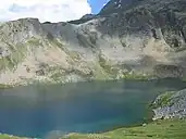
View of Ibón de Sabocos near Panticosa.
Alto Gállego (Aragonese: Alto Galligo) is a comarca located in the north of the autonomous community of Aragón, Spain. It occupies practically the entirety of the upper basin of the Río Gállego.
Historically the comarca was a part of the area known as Jacetania, the original nucleus of the old county of Aragón. The historical territories integrated into that area were the Tena Valley, the lands surrounding Biescas, and the Serrablo.
Today, Alto Gállego borders with the comarca of Jacetania to the West, the Sobrarbe to the East, the Hoya de Huesca, France to the North.
Territory and Population
| Municipality | Area (km2)[1] |
% of total |
Inhabitants (2006)[2] |
% of total |
Altitude (meters)[1] |
|---|---|---|---|---|---|
| Biescas | 189.1 | 13.9 | 1,513 | 11.2 | 860 |
| Caldearenas | 192.3 | 14.1 | 244 | 1.8 | 650 |
| Hoz de Jaca | 12.5 | 0.9 | 77 | 0.6 | 1,272 |
| Panticosa | 95.9 | 7.1 | 740 | 5.5 | 1,185 |
| Sabiñánigo | 586.8 | 43.2 | 9,264 | 68.8 | 780 |
| Sallent de Gállego | 162.1 | 11.9 | 1,384 | 10.3 | 1,305 |
| Yebra de Basa | 90.9 | 6.7 | 155 | 1.2 | 1,060 |
| Yésero | 30.2 | 2.2 | 80 | 0.6 | 1,132 |
| Totals | 1,359.8 | 100.0 | 13,457 | 100.0 | - |
See also
References
- 1 2 Figures from Instituto Aragonés de Estadística (IAEST). Complete Figures Archived 2009-01-18 at the Wayback Machine.
- ↑ Figures from the National Institute of Statistics (Spain), from January 1, 2006. Complete Figures Archived 2007-02-03 at the Wayback Machine.
External links
This article is issued from Wikipedia. The text is licensed under Creative Commons - Attribution - Sharealike. Additional terms may apply for the media files.