Ambri Airport | |||||||||||
|---|---|---|---|---|---|---|---|---|---|---|---|
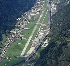
 Aerial view of the airport | |||||||||||
| Summary | |||||||||||
| Airport type | Private | ||||||||||
| Location | Quinto | ||||||||||
| Elevation AMSL | 3,214 ft / 980 m | ||||||||||
| Coordinates | 46°30′47″N 8°41′22″E / 46.51306°N 8.68944°E | ||||||||||
| Website | www.ambri-airport.com | ||||||||||
| Runways | |||||||||||
| |||||||||||
Sources: Ambri Airport official website | |||||||||||

Ambri Airport[lower-alpha 1] (ICAO: LSPM) is a Swiss general aviation airport. It located near the village of Ambrì, in the municipality of Quinto, canton of Ticino. Ambri serves the surrounding area and is home to a gliding school, a helicopter base and has sufficiency for VFR flying.
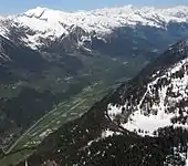
The airport is situated in the steep-sided alpine valley of the Ticino river. It is flanked to the north by the A2 motorway and the river, and to the south by the Gotthard railway and the villages of Ambri and Piotta.
History
Ambri Airport began as a Swiss Air Force base, built during World War II. It was home to the Fighter Squadron 8, whose fleet included the EKW C-35, Messerschmitt Bf 109, de Havilland Vampire, de Havilland Venom and the Hawker Hunter.[1]
The mountains surrounding the airport housed bunkers of which were home to tactical buildings, fighter aircraft and troops. The bunkers were accessed by taxiways that passed under the A2 motorway, and over the Ticino river.[1]
In 1994 the Swiss Air Force base was deactivated, and the airfield converted into a civilian airport. The Aircraft cavern that formerly accommodated the base still exists but are now empty.[1][2]
See also
References
- 1 2 3 "Home". Ambri Airport. Archived from the original on 2015-09-10. Retrieved 2012-11-06.
- ↑ "Ambri Airport". www.zone-interdite.net. Retrieved 2012-11-06.
Notes
External links
 Media related to Ambri Airport at Wikimedia Commons
- Official Website
- DH-112 Venom Take-off & landing at Ambri