Analalava District | |
|---|---|
District | |
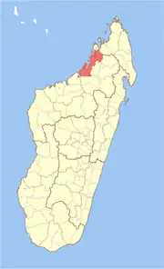 Location in Madagascar | |
| Coordinates: 14°34′S 47°54′E / 14.567°S 47.900°E | |
| Country | |
| Region | Sofia |
| Area | |
| • Total | 4,380 km2 (1,690 sq mi) |
| Population (2001) | |
| • Total | 89,917 |
| • Density | 20.5/km2 (53/sq mi) |
| • Ethnicities | Sakalava |
| Time zone | UTC3 (EAT) |
| Postal code | 405 |
Analalava is a district in northern Madagascar. It is a part of Sofia Region and borders the districts of Ambanja in northeast, Bealanana and Antsohihy in east and Boriziny (Port-Bergé) in south. The area is 4,380 km2 (1,691 sq mi) and the population was estimated to be 89,917 in 2001.[1]
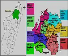
districts of Sofia
Communes
The district is further divided into 11 communes:
National Parks
- The Sahamalaza National Park is situated in the municipality of Analalava.
- Anjajavy Forest at Antonibe
References
- 1 2 "Madagascar Administrative units". GeoHive. Archived from the original on 2009-04-23. Retrieved 2008-02-29.
14°34′S 47°54′E / 14.567°S 47.900°E
Capital: Antsohihy | ||
| Analalava (11) (407) | 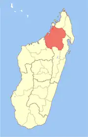 | |
| Antsohihy (12) (407) | ||
| Bealanana (13) (407) | ||
| Befandriana-Nord (12) (409) | ||
| Boriziny (15) (Port-Bergé) (419) |
| |
| Mampikony (6) (414) | ||
| Mandritsara (22) (415) | ||
7 districts; 91 communes | ||
This article is issued from Wikipedia. The text is licensed under Creative Commons - Attribution - Sharealike. Additional terms may apply for the media files.