Andapa District | |
|---|---|
District | |
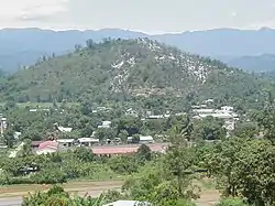 entrance of Andapa | |
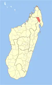 Location in Madagascar | |
| Coordinates: 14°39′S 49°39′E / 14.650°S 49.650°E | |
| Country | |
| Region | Sava |
| Area | |
| • Total | 4,051.48 km2 (1,564.29 sq mi) |
| Population (2013) | |
| • Total | 189,882 |
| • Density | 47/km2 (120/sq mi) |
| Time zone | UTC3 (EAT) |
| Postal code | 205 |
Andapa District is a district in northern Madagascar. It is a part of Sava Region and borders the districts of Ambilobe and Sambava to the north, Antalaha to the east, Maroantsetra to the south, and Befandriana Nord and Bealanana to the west. The area is 4,051.48 km2 (1,564 sq mi) and the population was estimated to be 189,882 in 2013.[1]
Communes
The district is further divided into 17 communes:
References and notes
- ↑ Institut National de la Statistique, Antananarivo.

This article is issued from Wikipedia. The text is licensed under Creative Commons - Attribution - Sharealike. Additional terms may apply for the media files.