Antón Díaz | |
|---|---|
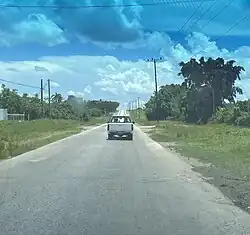 the Carretera Central passing though the ward of Anton Diaz | |
 Anton Diaz in Villa Clara | |
.svg.png.webp) Antón Díaz 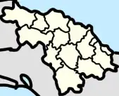 Antón Díaz _location_map.png.webp) Antón Díaz | |
| Coordinates: 22°24′45″N 80°02′22″W / 22.41250°N 80.03944°W | |
| Country | Cuba |
| Province | Villa Clara |
| Municipality | Santa Clara |
| Area | |
| • Total | 34 km2 (13 sq mi) |
| Population | |
| • Total | ~7,000 |
Antón Díaz is a ward (consejo popular) in Santa Clara, Cuba. It is located in the western part of Santa Clara.
Geography
.jpg.webp)
Ward (consejo popular) of Antón Díaz sign
Antón Díaz ward include the settlements of:[1][2][3]
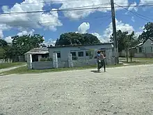
Building in La Gomera
- Las Minas
- La Gomera
- La Pulga
- CCS "Rubén Martínez Villena"
References
- 1 2 3 "Diaz-Canel, once again, visits communities in central Cuba". CubaSi.
- ↑ Francia, Bertha Pulido. "Accidente de transportación masiva en Villa Clara (+Audio y Fotos)". CMHW (in European Spanish). Retrieved 2023-04-10.
- ↑ "Construir el socialismo y defender la sociedad entre todos". www.juventudrebelde.cu (in Spanish). Retrieved 2023-04-10.
This article is issued from Wikipedia. The text is licensed under Creative Commons - Attribution - Sharealike. Additional terms may apply for the media files.