Anuradhapura District
අනුරාධපුර දිස්ත්රික්කය அனுராதபுரம் மாவட்டம் | |
|---|---|
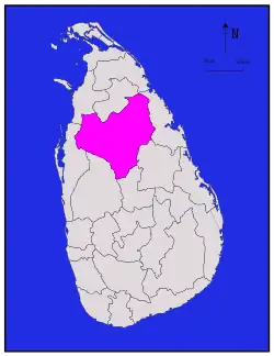
 Map of Sri Lanka with Anuradhapura District highlighted | |
| Coordinates: 8°20′N 80°30′E / 8.333°N 80.500°E | |
| Country | Sri Lanka |
| Province | North Central Province |
| Largest City | Anuradhapura |
| Divisions | List |
| Government | |
| • District Secretary | R. M. Wanninayake |
| Area | |
| • Total | 7,179 km2 (2,772 sq mi) |
| • Land | 6,664 km2 (2,573 sq mi) |
| • Water | 515 km2 (199 sq mi) |
| Population (2012)[1] | |
| • Total | 856,232 |
| • Density | 120/km2 (310/sq mi) |
| Time zone | UTC+05:30 (Sri Lanka) |
| ISO 3166 code | LK-71 |
| Website | ds.gov.lk/dist_anuradhapura |
Anuradhapura (Sinhala: අනුරාධපුර දිස්ත්රික්කය anūrādhapūra distrikkaya; Tamil: அனுராதபுரம் மாவட்டம் Aṉurātapuram māvaṭṭam) is a district in North Central Province, Sri Lanka. Its area is 7,179 km².
Major cities
- Anuradhapura (Municipal Council)
Other towns
- Bulnewa
- Eppawala
- Galenbindunuwewa
- Galnewa
- Ganewalpola
- Habarana
- Horowupotana
- Kahatagasdigiliya
- Kebitigollawa
- Kekirawa
- Konapathirawa
- Konwewa
- Madatugama
- Mahailuppallama
- Maradankadawala
- Medawachchiya
- Mihintale
- Nochchiyagama
- Nachchaduwa
- Padawiya
- Palugaswewa
- Rambewa
- Seeppukulama
- Talawa
- Tambuttegama
- Thirappane
- Yakalla
Anuradhapura district election divisions
Demographics
| Ethnic groups | |||
|---|---|---|---|
| Sinhalese | 676,073 | (90.66%) | |
| Sri Lankan Tamil | 5,073 | (0.68%) | |
| Sri Lankan Moor | 61,989 | (8.31%) | |
| Indian Tamil | 443 | (0.06%) | |
| Burgher | 179 | (0.02%) | |
| Sri Lankan Malay | 279 | (0.04%) | |
| Other | 1,657 | (0.22%) | |
| Religions | |||
|---|---|---|---|
| Buddhism | 670,963 | (89.98%) | |
| Hinduism | 3,459 | (0.46%) | |
| Islam | 62,797 | (8.42%) | |
| Roman Catholic | 6,266 | (0.84%) | |
| Other Christian | 2,073 | (0.28%) | |
| Other | 135 | (0.02%) | |
Religion in Anuradhapura District (2011)[1]
The population according to the 2001 census is 745,693, of whom 90.7% were Sinhalese, 8.3% Sri Lankan Moors, 0.7% native Sri Lankan Tamils and 0.1% Tamils of Indian origin. 90.0% of the population are Buddhists, 8.4% Muslim, 1.1% Christian and 0.5% Hindu.[2]
Divisional secretariats
Divisional secretariats constitute the next administrative division down from district.
- Anuradapura Divisional Secretariat
- Galenbindunuwewa Divisional Secretariat
- Galnewa Divisional Secretariat
- Horowpothana Divisional Secretariat
- Ipalogama Divisional Secretariat
- Kahatagasdigiliya Divisional Secretariat
- Kebithigollewa Divisional Secretariat
- Kekirawa Divisional Secretariat
- Mahavilachchiya Divisional Secretariat
- Medawachchiya Divisional Secretariat
- Mihinthale Divisional Secretariat
- Nachchadoowa Divisional Secretariat
- Nochchiyagama Divisional Secretariat
- Nuwaragam Palatha Central Divisional Secretariat
- Nuwaragam Palatha East Divisional Secretariat
- Padaviya Divisional Secretariat
- Palagala Divisional Secretariat
- Palugaswewa Divisional Secretariat
- Rajanganaya Divisional Secretariat
- Rambewa Divisional Secretariat
- Thalawa Divisional Secretariat
- Thambuttegama Divisional Secretariat
- Thirappane Divisional Secretariat
Maps
References
- 1 2 Department of Census and Statistics,The Census of Population and Housing of Sri Lanka-2011
- ↑ Department of Census and Statistics - official government website
This article is issued from Wikipedia. The text is licensed under Creative Commons - Attribution - Sharealike. Additional terms may apply for the media files.