Arak County
Persian: شهرستان اراک | |
|---|---|
County | |
 | |
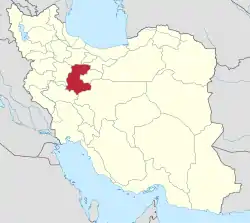
 Location of Arak County in Markazi province (bottom center, green) | |
 Location of Markazi province in Iran | |
| Coordinates: 34°08′42″N 49°51′00″E / 34.14500°N 49.85000°E[1] | |
| Country | |
| Province | Markazi |
| Capital | Arak |
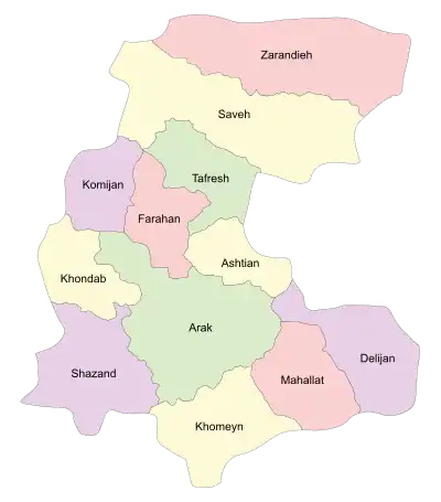
| Districts | Central, Masumiyeh, Saruq |
| Population (2016)[2] | |
| • Total | 591,756 |
| Time zone | UTC+3:30 (IRST) |
| Arak County can be found at GEOnet Names Server, at this link, by opening the Advanced Search box, entering "9207282" in the "Unique Feature Id" form, and clicking on "Search Database". | |
Arak County (Persian: شهرستان اراک) is in Markazi province, Iran. Its capital is the city of Arak (formerly Sultanabad).[3]
At the 2006 census, the county's population was 602,971 in 165,955 households.[4] The following census in 2011 counted 599,634 people in 182,749 households, by which time Khondab District had been separated from the county to form Khondab County.[5] At the 2016 census, the county's population was 591,756 in 188,180 households.[2]
Administrative divisions
The population history and structural changes of Arak County's administrative divisions over three consecutive censuses are shown in the following table. The latest census shows three districts, 11 rural districts, and four cities.[2]
| Administrative Divisions | 2006[4] | 2011[5] | 2016[2] |
|---|---|---|---|
| Central District | 543,859 | 571,933 | 565,357 |
| Amanabad RD | 4,682 | 4,205 | 4,108 |
| Amiriyeh RD | 7,532 | 8,664 | 7,379 |
| Davudabad RD | 3,039 | 2,522 | 2,748 |
| Hajjiabad RD | 5,127 | 4,699 | |
| Mashhad-e Miqan RD | 8,830 | 5,444 | 6,963 |
| Masumiyeh RD | 11,453 | ||
| Moshkabad RD | 7,339 | ||
| Saruq RD | 8,410 | ||
| Sedeh RD | 8,724 | 8,966 | 8,103 |
| Shamsabad RD | 6,004 | 5,571 | 4,922 |
| Arak (city) | 438,338 | 484,212 | 520,944 |
| Davudabad (city) | 5,517 | 5,252 | 5,491 |
| Karahrud (city)1 | 23,399 | 29,721 | |
| Senjan (city)1 | 10,592 | 12,249 | |
| Khondab District2 | 59,112 | ||
| Deh Chal RD | 9,583 | ||
| Enaj RD | 11,706 | ||
| Javersiyan RD | 13,045 | ||
| Khondab RD | 9,127 | ||
| Sang Sefid RD | 8,669 | ||
| Khondab (city) | 6,982 | ||
| Masumiyeh District | 16,373 | 15,889 | |
| Masumiyeh RD | 5,859 | 5,697 | |
| Moshkabad RD | 6,762 | 6,449 | |
| Karchan (city) | 3,752 | 3,743 | |
| Saruq District | 11,328 | 10,491 | |
| Mashhad ol Kubeh RD | 3,264 | 2,980 | |
| Saruq RD | 6,678 | 6,166 | |
| Saruq (city) | 1,386 | 1,345 | |
| Total | 602,971 | 599,634 | 591,756 |
| RD: Rural District 1Merged with the city of Arak[6] 2Became a part of Khondab County | |||

Wikimedia Commons has media related to Arak County.
References
- ↑ OpenStreetMap contributors (29 August 2023). "Arak County" (Map). OpenStreetMap. Retrieved 29 August 2023.
- 1 2 3 4 "Census of the Islamic Republic of Iran, 1395 (2016)". AMAR (in Persian). The Statistical Center of Iran. p. 00. Archived from the original (Excel) on 17 October 2020. Retrieved 19 December 2022.
- ↑ Gitashenasi Province Atlas of Iran
اطلس گیتاشناسی استانهای ایران Archived May 22, 2007, at the Wayback Machine - 1 2 "Census of the Islamic Republic of Iran, 1385 (2006)". AMAR (in Persian). The Statistical Center of Iran. p. 00. Archived from the original (Excel) on 20 September 2011. Retrieved 25 September 2022.
- 1 2 "Census of the Islamic Republic of Iran, 1390 (2011)" (Excel). Iran Data Portal (in Persian). The Statistical Center of Iran. p. 00. Retrieved 19 December 2022.
- ↑ Rahimi, Mohammad Reza (25 November 2013). "Approval letter regarding country divisions in Markazi province". Islamic Parliament Research Center (in Persian). Ministry of Interior, Council of Ministers. Archived from the original on 8 December 2015. Retrieved 29 August 2023.
Markazi Province, Iran | |||||||||||||||||||||||||
|---|---|---|---|---|---|---|---|---|---|---|---|---|---|---|---|---|---|---|---|---|---|---|---|---|---|
| Capital | 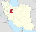 | ||||||||||||||||||||||||
| Counties and cities |
| ||||||||||||||||||||||||
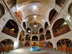
| Sights |
| ||||||||||||||||||||||||
| populated places | |||||||||||||||||||||||||
| Capital | |||||||||||||||||||||||
|---|---|---|---|---|---|---|---|---|---|---|---|---|---|---|---|---|---|---|---|---|---|---|---|
| Districts |
| ||||||||||||||||||||||
This article is issued from Wikipedia. The text is licensed under Creative Commons - Attribution - Sharealike. Additional terms may apply for the media files.