Arlington Municipal Airport | |||||||||||
|---|---|---|---|---|---|---|---|---|---|---|---|
 | |||||||||||
| Summary | |||||||||||
| Airport type | Public | ||||||||||
| Operator | City of Arlington | ||||||||||
| Serves | Arlington, Texas | ||||||||||
| Elevation AMSL | 628 ft / 191 m | ||||||||||
| Coordinates | 32°39′50″N 097°05′39″W / 32.66389°N 97.09417°W | ||||||||||
| Website | |||||||||||
| Map | |||||||||||
 GKY  GKY | |||||||||||
| Runways | |||||||||||
| |||||||||||
| Statistics (2006) | |||||||||||
| |||||||||||
Arlington Municipal Airport (ICAO: KGKY, FAA LID: GKY) is five miles south of Arlington, in Tarrant County, Texas.[1] The airport is at the intersection of Interstate 20 and South Collins Road; it is a reliever airport for Dallas/Fort Worth International Airport and Dallas Love Field.
Several companies operate aircraft services on the airport property, including the Bell Helicopter division of Textron.
Most U.S. airports use the same three-letter location identifier for the FAA and IATA, but this airport GKY to the FAA and has no IATA code.[2]
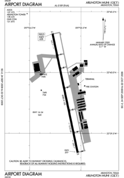
Facilities
The airport covers 500 acres (200 ha) at an elevation of 628 feet (191 m). Its single runway, 16/34, is 6,080 by 100 feet (1,853 x 30 m) concrete.[1]
In 2006 the airport had 151,600 aircraft operations, average 415 per day: 97% general aviation, 3% air taxi and <1% military. 250 aircraft were then based at this airport: 70% single-engine, 22% multi-engine, 6% helicopter and 2% jet.[1]
See also
References
- 1 2 3 4 FAA Airport Form 5010 for GKY PDF, effective 2009-05-07.
- ↑ Great Circle Mapper: KGKY - Arlington, Texas
External links
- Arlington Municipal Airport, official site
- FAA Airport Diagram (PDF), effective December 28, 2023
- FAA Terminal Procedures for GKY, effective December 28, 2023
- Resources for this airport:
- FAA airport information for GKY
- AirNav airport information for KGKY
- FlightAware airport information and live flight tracker
- NOAA/NWS weather observations: current, past three days
- SkyVector aeronautical chart, Terminal Procedures
| Education |
| ||||
|---|---|---|---|---|---|
| Landmarks | |||||
| Transportation | |||||
| History | |||||
| |||||