Asbury Township | |
|---|---|
 Wheat harvest along New Haven-Shawneetown Road | |
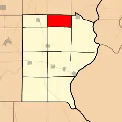 Location in Gallatin County | |
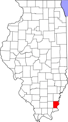 Gallatin County's location in Illinois | |
| Coordinates: 37°53′16″N 88°12′45″W / 37.88778°N 88.21250°W | |
| Country | United States |
| State | Illinois |
| County | Gallatin |
| Established | November 5, 1890 |
| Area | |
| • Total | 17.82 sq mi (46.2 km2) |
| • Land | 17.79 sq mi (46.1 km2) |
| • Water | 0.03 sq mi (0.08 km2) 0.17% |
| Elevation | 410 ft (125 m) |
| Population (2010) | |
| • Estimate (2016)[1] | 99 |
| • Density | 5.9/sq mi (2.3/km2) |
| Time zone | UTC-6 (CST) |
| • Summer (DST) | UTC-5 (CDT) |
| ZIP codes | 62867, 62871 |
| FIPS code | 17-059-02427 |
Asbury Township is one of ten townships in Gallatin County, Illinois, USA. As of the 2010 census, its population was 105 and it contained 51 housing units.[2]
Geography
According to the 2010 census, the township has a total area of 17.82 square miles (46.2 km2), of which 17.79 square miles (46.1 km2) (or 99.83%) is land and 0.03 square miles (0.078 km2) (or 0.17%) is water.[2]
Unincorporated towns
(This list is based on USGS data and may include former settlements.)
Cemeteries
The township contains these two cemeteries: Cottonwood Presbyterian Church and Swan.
Demographics
| Census | Pop. | Note | %± |
|---|---|---|---|
| 2016 (est.) | 99 | [1] | |
| U.S. Decennial Census[3] | |||
School districts
- Gallatin Community Unit School District 7
Political districts
- Illinois' 15th congressional district
- State House District 118
- State Senate District 59
References
- "Asbury Township, Gallatin County, Illinois". Geographic Names Information System. United States Geological Survey, United States Department of the Interior. Retrieved January 17, 2010.
- United States Census Bureau 2007 TIGER/Line Shapefiles
- United States National Atlas
- 1 2 "Population and Housing Unit Estimates". Retrieved June 9, 2017.
- 1 2 "Population, Housing Units, Area, and Density: 2010 - County -- County Subdivision and Place -- 2010 Census Summary File 1". United States Census. Archived from the original on February 12, 2020. Retrieved May 28, 2013.
- ↑ "Census of Population and Housing". Census.gov. Retrieved June 4, 2016.
External links
Places adjacent to Asbury Township, Gallatin County, Illinois | |
|---|---|
Municipalities and communities of Gallatin County, Illinois, United States | ||
|---|---|---|
| City | Map of Illinois highlighting Gallatin County | |
| Villages | ||
| Townships | ||
| Unincorporated communities | ||
This article is issued from Wikipedia. The text is licensed under Creative Commons - Attribution - Sharealike. Additional terms may apply for the media files.