| Atalaya Mountain | |
|---|---|
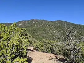
 Atalaya Mountain from Atalaya Trail | |
| Highest point | |
| Elevation | 9,125 ft (2,781 m) NAVD 88[1] |
| Prominence | 721 ft (220 m)[1] |
| Coordinates | 35°40′04″N 105°52′35″W / 35.667693°N 105.876366°W[1] |
| Geography | |
| Location | Santa Fe County, New Mexico, U.S. |
| Parent range | Santa Fe Mountains Sangre de Cristo Range Southern Rocky Mountains |
| Topo map | USGS Santa Fe |
| Climbing | |
| Easiest route | trail hike |
Atalaya Mountain is a mountain peak located within the Santa Fe National Forest, in northern New Mexico, United States. It is part of the Santa Fe Mountains in the Sangre de Cristo Range, a subrange of the Southern Rocky Mountains. A relevant viewscape from the city of Santa Fe, there are no higher peaks between the city and Atalaya Mountain to the east. Viewed from the city, Atalaya Mountain is framed by Sun Mountain to the right (south), Picacho Peak to the left (north), and Thompson Peak behind it. Atalaya Mountain is accessible by following the Atalaya Trail,[2] or via the Dale Ball Trails from the direction of Picacho Peak and trail marker number 36.
 trailhead sign |
.jpg.webp) view from Atalaya |
Toponymic Note
Atalaya is a spanish term meaning Watchtower. Variant names include Cerro Atalaya, and Cerro de la Atalaya. In the Tewa language, Ogapogeping, and Pogeping.[3]
References
- 1 2 3 "Atalaya Mountain, New Mexico". Peakbagger.com. Retrieved 21 May 2020.
- ↑ "Atalaya Mountain Trail". alltrails.com.
- ↑ U.S. Geological Survey Geographic Names Information System: Atalaya Mountain
External links
- City of Santa Fe - Trails & Maps
- Atalaya Trail #170, Santa Fe National Forest, usda.gov
- NM HOUSE MEMORIAL 88 recognizing the Contributions of Dale Ball