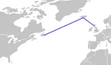
The Atlantic Bridge is a flight route from Gander, Newfoundland, Canada to Scotland, with a refueling stop in Iceland.
During the Second World War, new bombers flew this route. Today, it is seldom used for commercial aviation, since modern jet airliners can fly a direct route from Canada or the United States to Europe without the need for a fueling stop. However, smaller aircraft which do not have the necessary range to make a direct crossing of the ocean still routinely use this route, or may alternatively stop in Greenland, typically via Narsarsuaq and Kulusuk or the Azores for refueling. The most common users of this route are ferry pilots delivering light aeroplanes (often six seats or less) to new owners. Smaller commercial jet airliners with insufficient range to make the crossing were once ferried this way but is becoming less common as fuel efficiency has improved over the years - for example the latest versions of the Boeing 737 and Airbus A320 can now comfortably cross the ocean directly with no need for a refuelling stop.
This route is longer overall than the direct route and involves an extra landing and takeoff, which is costly in fuel terms, however the Icelandic carrier Icelandair strongly markets the Atlantic Bridge as part of its business model by joining major US and Canadian hubs with Western European destinations via its base at Keflavík International Airport.
See also
References
- Atlantic Bridge: the Official Account of RAF Transport Command's Ocean Ferry, HM Stationery Office, 1945