| Augstenberg | |
|---|---|
| Piz Blaisch Lunga | |
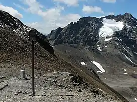
 Augstenberg on the right. | |
| Highest point | |
| Elevation | 3,230 m (10,600 ft) |
| Prominence | 432 m (1,417 ft)[1] |
| Parent peak | Piz Buin |
| Isolation | 3.2 km (2.0 mi) |
| Listing | Alpine mountains above 3000 m |
| Coordinates | 46°51′52″N 10°12′13″E / 46.864444°N 10.203611°E |
| Geography | |
 Augstenberg Location in the Alps | |
| Location | Graubünden, Switzerland/Tyrol, Austria |
| Parent range | Silvretta Alps |
| Climbing | |
| First ascent | 23 August 1881 by C. Blezinger and E. Renner, guided by Peter Reinstadler and the brothers Lorenz. |
The Augstenberg (also known as Piz Blaisch Lunga) is a mountain of the Silvretta Alps, located on the border between Austria and Switzerland. It has an elevation of 3,230 metres (10,597 ft) above sea level. A secondary summit on the south has an elevation of 3,225 metres. On its eastern side the Augstenberg overlooks the Pass Futschöl (2,768 m).
References
External links
This article is issued from Wikipedia. The text is licensed under Creative Commons - Attribution - Sharealike. Additional terms may apply for the media files.