| Aujon | |
|---|---|
.jpg.webp) The Aujon, with a wash house, at Longchamp-sur-Aujon. | |
 | |
| Location | |
| Country | France |
| Physical characteristics | |
| Source | |
| • location | Perrogney-les-Fontaines |
| • coordinates | 47°48′50″N 05°10′46″E / 47.81389°N 5.17944°E |
| • elevation | 430 m (1,410 ft) |
| Mouth | |
• location | Aube |
• coordinates | 48°09′20″N 04°47′50″E / 48.15556°N 4.79722°E |
• elevation | 185 m (607 ft) |
| Length | 68 km (42 mi) |
| Basin size | 480 km2 (190 sq mi) |
| Discharge | |
| • average | 6.45 m3/s (228 cu ft/s) |
| Basin features | |
| Progression | Aube→ Seine→ English Channel |
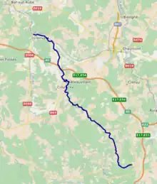
The Aujon (French pronunciation: [oʒɔ̃]) is a 68 km (42 mi) long river in the Haute-Marne and Aube departments in northeastern France.[1] Its source is at Perrogney-les-Fontaines. It flows generally northwest. It is a right tributary of the Aube into which it flows at Longchamp-sur-Aujon.
Departments and communes along its course
This list is ordered from source to mouth:
References
Wikimedia Commons has media related to Aujon.
This article is issued from Wikipedia. The text is licensed under Creative Commons - Attribution - Sharealike. Additional terms may apply for the media files.