| Ayu-Dag | |
|---|---|
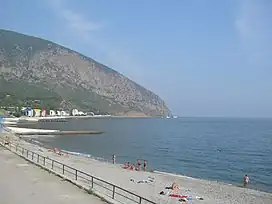 Ayu-Dag. View from Artek's beach | |
| Highest point | |
| Elevation | 572 m (1,877 ft) |
| Coordinates | 44°33′N 34°20′E / 44.550°N 34.333°E |
| Geography | |
| Location | Crimea |
| Parent range | Crimean Mountains |
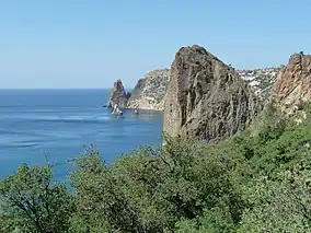
Ayu-Dag (Crimean Tatar: Ayuv Dağ, Ukrainian: Аю-Даг, Russian: Аю-Даг, Greek: Αγια (Aya - "Holy"[1])) is a summit of Crimea. It is also known under the Russified name Medved'-gora (Bear mountain) (Ukrainian: Ведмідь-гора, Russian: Медведь-гора). The summit is located 16 km north-east from Yalta between the towns of Gurzuf and Partenit.
Its Ancient Greek name was Κριοῦ μέτωπον (Kriou Metopon), meaning Ram's Head.[2] The Slavic language variants of the mountain's name are translations from the Crimean Tatar name and mean Bear Mountain ("bear"- ведмідь in Ukrainian, медведь in Russian, ayuv in Crimean Tatar; "mountain"-гора in Ukrainian and Russian, dağ in Crimean Tatar).
The mountain is a laccolith. Today its territory is a Nature reserve (5.5 km2). There is a pioneer children's camp Artek near Ayu-Dag which is well known internationally. The eastern slopes of Ayu-Dag lead to an ancient settlement Partenit.
Remains of an early-medieval settlement and a number of churches were discovered here. In the 9th-10th centuries it was a well-known seaport, bound with cities of the Byzantine Empire. The western slopes lead to Artek.
References
| Mountains |  | |
|---|---|---|
| Passes | ||
| Landforms | ||
| Palaces | ||
| Fortresses | ||
| Ancient cities | ||
| Others | ||
| Botanical nature reserves |
|  |
|---|---|---|
| Geological nature reserves |
| |
| Hydrological nature reserves |
| |
| Landscape nature reserves |
| |
| Forest nature reserves | ||
| Ornithological nature reserves |
| |
Categories of protected areas of Ukraine The Crimean peninsula is recognised internationally as part of Ukraine, but is under Russian occupation since 2014. | ||