Bělá | |
|---|---|
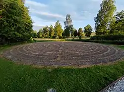
 Christian Labyrinth | |
 Flag _CoA_CZ.jpg.webp) Coat of arms | |
 Bělá Location in the Czech Republic | |
| Coordinates: 49°58′20″N 18°8′42″E / 49.97222°N 18.14500°E | |
| Country | |
| Region | Moravian-Silesian |
| District | Opava |
| First mentioned | 1349 |
| Area | |
| • Total | 2.86 km2 (1.10 sq mi) |
| Elevation | 243 m (797 ft) |
| Population (2023-01-01)[1] | |
| • Total | 669 |
| • Density | 230/km2 (610/sq mi) |
| Time zone | UTC+1 (CET) |
| • Summer (DST) | UTC+2 (CEST) |
| Postal code | 747 23 |
| Website | www |
Bělá (German: Bielau, Polish: Biała) is a municipality and village in Opava District in the Moravian-Silesian Region of the Czech Republic. It has about 700 inhabitants. It is part of the historic Hlučín Region.
History
The first written mention of Bělá is from 1349.[2]
During the World War II, the German occupiers operated the E116 forced labour subcamp of the Stalag VIII-B/344 prisoner-of-war camp in the village.[3]
References
- ↑ "Population of Municipalities – 1 January 2023". Czech Statistical Office. 2023-05-23.
- ↑ "Historie obce" (in Czech). Obec Bělá. Retrieved 2022-03-03.
- ↑ "Working Parties". Lamsdorf.com. Archived from the original on 29 October 2020. Retrieved 13 November 2021.
External links
Wikimedia Commons has media related to Bělá (Opava District).
This article is issued from Wikipedia. The text is licensed under Creative Commons - Attribution - Sharealike. Additional terms may apply for the media files.