| Developer(s) | Ramesh Dhungel and group |
|---|---|
| Written in | Python (programming language), shell script, GDAL, numpy |
| Operating system | Microsoft Windows |
| Type | Evapotranspiration modeling, irrigation simulation, surface temperature simulation, soil moisture simulation, Geographic information system |
BAITSSS (Backward-Averaged Iterative Two-Source Surface temperature and energy balance Solution) is biophysical Evapotranspiration (ET) computer model that determines water use, primarily in agriculture landscape, using remote sensing-based information.[1] It was developed and refined by Ramesh Dhungel and the water resources group at University of Idaho's Kimberly Research and Extension Center since 2010. It has been used in different areas in the United States including Southern Idaho, Northern California, northwest Kansas, Texas, and Arizona.
History of development
BAITSSS originated from the research of Ramesh Dhungel, a graduate student at the University of Idaho,[2] who joined a project called "Producing and integrating time series of gridded evapotranspiration for irrigation management, hydrology and remote sensing applications" under professor Richard G. Allen.[3]
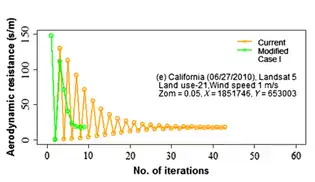
In 2012, the initial version of landscape model was developed using the Python IDLE environment using NARR weather data (~ 32 kilometers).[1] Dhungel submitted his PhD dissertation in 2014 where the model was called BATANS (backward averaged two source accelerated numerical solution).[1][2] The model was first published in Meteorological Applications journal in 2016 under the name BAITSSS as a framework to interpolate ET between the satellite overpass when thermal based surface temperature is unavailable.[1] The overall concept of backward averaging was introduced to expedite the convergence process of iteratively solved surface energy balance components which can be time-consuming and can frequently suffer non-convergence, especially in low wind speed.[1]
In 2017, the landscape BAITSSS model was scripted in Python shell, together with GDAL and NumPy libraries using NLDAS weather data (~ 12.5 kilometers).[1] The detailed independent model was evaluated against weighing lysimeter measured ET, infrared temperature (IRT) and net radiometer of drought‐tolerant corn and sorghum at Conservation and Production Research Laboratory in Bushland, Texas by group of scientists from USDA-ARS and Kansas State University between 2017 and 2020.[1] Some later development of BAITSSS includes physically based crop productivity components, i.e. biomass and crop yield computation.[1][4][5]
Rationale
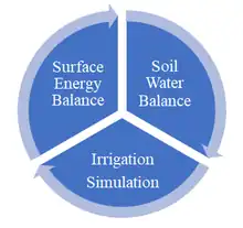
The majority of remote sensing based instantaneous ET models use evaporative fraction (EF) or reference ET fraction (ETrF), similar to crop coefficients, for computing seasonal values, these models generally lack the soil water balance and Irrigation components in surface energy balance.[1] Other limiting factors is the dependence on thermal-based radiometric surface temperature, which is not always available at required temporal resolution and frequently obscured by factors such as cloud cover.[1][6] BAITSSS was developed to fill these gaps in remote sensing based models liberating the use of thermal-based radiometric surface temperature and to serve as a digital crop water tracker simulating high temporal (hourly or sub-hourly) and spatial resolution (30 meter) ET maps.[1][7][8] BAITSSS utilizes remote sensing based canopy formation information, i.e. estimation of seasonal variation of vegetation indices and senescence.[1]
Approach and model structure
Surface energy balance is one of the commonly utilized approaches to quantify ET (latent heat flux in terms of flux), where weather variables and vegetation Indices are the drivers of this process. BAITSSS adopts numerous equations to compute surface energy balance and resistances where primarily are from Javis, 1976,[9] Choudhury and Monteith, 1988,[10] and aerodynamic methods or flux-gradient relationship equations[11][12] with stability functions associated with Monin–Obukhov similarity theory.
Underlying fundamental equations of surface energy balance
Latent heat flux (LE)
The aerodynamic or flux-gradient equations of latent heat flux in BAITSSS are shown below. is saturation vapor pressure at the canopy and is for soil, is ambient vapor pressure, rac is bulk boundary layer resistance of vegetative elements in the canopy, rah is aerodynamic resistance between zero plane displacement (d) + roughness length of momentum (zom) and measurement height (z) of wind speed, ras is the aerodynamic resistance between the substrate and canopy height (d +zom), and rss is soil surface resistance.[1]
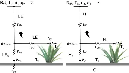
Sensible heat flux (H) and surface temperature calculation[1]
The flux-gradient equations of sensible heat flux and surface temperature in BAITSSS are shown below.
Canopy resistance (rsc)
Typical Jarvis type-equation of rsc adopted in BAITSSS is shown below, Rc-min is the minimum value of rsc, LAI is leaf area index, fc is fraction of canopy cover, weighting functions representing plant response to solar radiation (F1), air temperature (F2), vapor pressure deficit (F3), and soil moisture (F4) each varying between 0 and 1.[1]
Equations of soil water balance and irrigation decision
Standard soil water balance equations for soil surface and the root zone are implemented in BAITSSS for each time step, where irrigation decisions are based on the soil moisture at the root zone.[1]
Data
Input

ET models, in general, need information about vegetation (physical properties and vegetation indices) and environment condition (weather data) to compute water use. Primary weather data requirements in BAITSSS are solar irradiance (Rs↓), wind speed (uz), air temperature (Ta), relative humidity (RH) or specific humidity (qa), and precipitation (P). Vegetation indices requirements in BAITSSS are leaf area index (LAI) and fractional canopy cover (fc), generally estimated from normalized difference vegetation index (NDVI). Automated BAITSSS [1] can compute ET throughout United States using National Oceanic and Atmospheric Administration (NOAA) weather data (i.e. hourly NLDAS: North American Land Data Assimilation system at 1/8 degree; ~ 12.5 kilometers), Vegetation indices those acquired by Landsat, and soil information from SSURGO.
Output
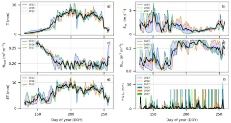
BAITSSS generates large numbers of variables (fluxes, resistances, and moisture) in gridded form in each time-step. The most commonly used outputs are evapotranspiration, evaporation, transpiration, soil moisture, irrigation amount, and surface temperature maps and time series analysis.
Model features
| Feature | Description |
|---|---|
| Two-source energy balance | BAITSSS is a two-source energy balance model (separate soil and canopy section) which is integrated by fraction of vegetation cover (fc) based on vegetation indices. |
| Two-layers soil water balance | BAITSSS simulates soil surface moisture (θsur) and root zone moisture (θroot) layers are related to the dynamics of evaporative (Ess) and transpirative (T) flux. Capillary rise (CR) from the layer below root zone into the root zone layer is neglected. The soil moisture at both layers is restricted to field capacity (θfc). |
| Surface temperature | BAITSSS iteratively solves surface temperature inverting flux-gradient equations of H at the soil surface (subscript s) (Ts) and canopy level (subscript c) (Tc) for each time step using continuous weather variables and surface roughness defined by vegetation Indices. |
| Ground heat flux of soil | BAITSSS estimates ground heat flux (G) of soil surface based on sensible heat flux (Hs) or net radiation (Rn_s) of soil surface and neglects G on vegetated surface. |
| Transpiration | Variable canopy conductance in terms of canopy resistance (rsc), based on the Jarvis-type algorithm is used to compute transpiration. |
| Evaporation | Evaporation (Ess) in BAITSSS is computed based on soil resistance (rss) and soil water content in soil surface layer (upper 100 millimeters of soil water balance). |
| Irrrigation | BAITSSS simulates irrigation (Irr) in agricultural landscapes[13][14] by mimicking a tipping-bucket approach (applied to surface as sprinkler or sub-surface layer as drip), using Management Allowed Depletion (MAD), and soil water content regimes at rooting depth (lower 100-2000 millimeters of soil layer). |
| Biomass and Yield | BAITSSS computes above biomass from transpiration efficiency normalized by vapor pressure deficit and grain fraction by empirical function of biomass. |
Agriculture system applications and recognition
BAITSSS was implemented to compute ET in southern Idaho for 2008, and in northern California for 2010.[1] It was used to calculate corn and sorghum ET in Bushland, Texas for 2016, and multiple crops in northwest Kansas for 2013–2017.[1][15][16][4] BAITSSS has been widely discussed among the peers around the world, including Bhattarai et al. in 2017 and Jones et al. in 2019.[17] United States Senate Committee on Agriculture, Nutrition and Forestry listed BAITSSS in its climate change report.[18] BAITSSS was also covered by articles in Open Access Government,[6][19] Landsat science team,[20] Grass & Grain magazine,[21] National Information Management & Support System (NIMSS), [22] terrestrial ecological models, [23] key research contribution related to sensible heat flux estimation and irrigation decision in remote sensing based ET models.[24][25]
In September 2019, the Northwest Kansas Groundwater Management District 4 (GMD 4) along with BAITSSS received national recognition from American Association for the Advancement of Science (AAAS).[26][27][15][28][29][30] AAAS highlighted 18 communities across the U.S. that are responding to climate change[31][32][33] including Sheridan County, Kansas to prolong the life of Ogallala Aquifer by minimizing water use where this aquifer is depleting rapidly due to extensive agricultural practices . AAAS discussed the development and use of intricate ET model BAITSSS and Dhungel's and other scientists efforts supporting effective use of water in Sheridan County, Kansas.[15]
Furthermore, Upper Republican Regional Advisory Committee of Kansas (June 2019)[16] and GMD 4[34] discussed possible benefit and utilization of BAITSSS for managing water use, educational purpose, and cost-share. A short story about Ogallala Aquifer Conservation effort from Kansas State University and GMD4 using ET model was published in Mother Earth News (April/May 2020),[35] and Progressive Crop Consultant.[36]
Example application
Groundwater and Irrigation
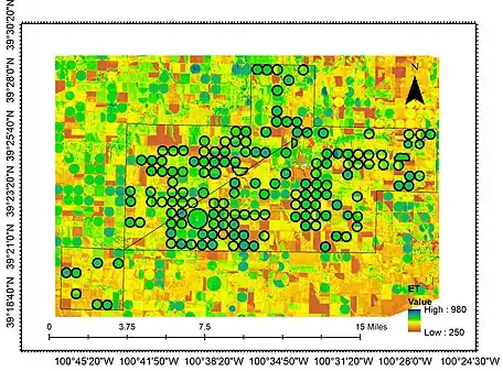
Dhungel et al., 2020,[1] combined with field crop scientists, systems analysts, and district water managers, applied BAITSSS at the district water management level focusing on seasonal ET and annual groundwater withdrawal rates at Sheridan 6 (SD-6) Local Enhanced Management Plan (LEMA) for five years period (2013-2017) in northwest, Kansas, United States. BAITSSS simulated irrigation was compared to reported irrigation as well as to infer deficit irrigation within water right management units (WRMU). In Kansas, groundwater pumping records are legal documents and maintained by the Kansas Division of Water Resources. The in-season water supply was compared to BAITSSS simulated ET as well-watered crop water condition.
Evapotranspiration Hysterisis and Advection
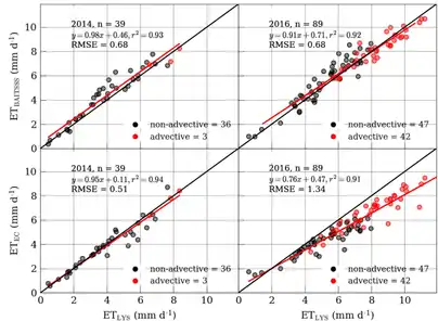
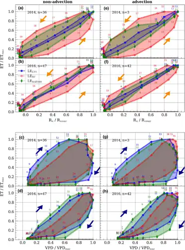
A study related to ET uncertainty associated with ET hysteresis (Vapor pressure and net radiation) were conducted using lysimeter, Eddy covariance (EC), and BAITSSS model (point-scale) in an advective environment of Bushland, Texas.[1] Results indicated that the pattern of hysteresis from BAITSSS closely followed the lysimeter and showed weak hysteresis related to net radiation when compared to EC. However, both lysimeter and BAITSSS showed strong hysteresis related to VPD when compared to EC.
Lettuce Evapotranspiration
A study related to lettuce evapotranspiration was conducted at Yuma, Arizona using BAITSSS between 2016 and 2020, where model simulated ET closely followed twelve eddy covariance sites [14]
Challenges and limitations
Simulation of hourly ET at 30 m spatial resolution for seasonal time scale is computationally challenging and data-intensive.[1][37] The low wind speed complicates the convergence of surface energy balance components as well.[1] The peer group Pan et al. in 2017 [14] and Dhungel et al., 2019 [1] pointed out the possible difficulty of parameterization and validations of these kinds of resistance based models. The simulated irrigation may vary than that actually applied in field.[1]
See also
- METRIC, another model developed by University of Idaho that uses Landsat satellite data to compute and map evapotranspiration
- SEBAL, uses the surface energy balance to estimate aspects of the hydrological cycle. SEBAL maps evapotranspiration, biomass growth, water deficit and soil moisture
References
- 1 2 3 4 5 6 7 8 9 10 11 12 13 14 15 16 17 18 19 20 21 22 23 24 25 Peer reviewed papers from Dhungel and others:
- Dhungel, Ramesh; Allen, Richard G.; Trezza, Ricardo; Robison, Clarence W. (2016). "Evapotranspiration between satellite overpasses: methodology and case study in agricultural dominant semi-arid areas". Meteorological Applications (published October 2016). 23 (4): 714–730. Bibcode:2016MeApp..23..714D. doi:10.1002/met.1596. ISSN 1469-8080.
- Dhungel, Ramesh; Aiken, Robert; Colaizzi, Paul; Lin, Xiaomao; Baumhardt, Roland; Brauer, David; Marek, Gary; Evett, Steven; O'Brien, Dan (April 11, 2019). "Increased bias in evapotranspiration modeling due to weather and vegetation indices data sources". Agronomy Journal. 111 (3): 1407–1424. doi:10.2134/agronj2018.10.0636. Retrieved 2019-04-09 – via Agricultural Research Service.
- Dhungel, Ramesh; Aiken, Robert; Colazzi, Paul D.; Lin, Xiaomao; O'Brien, Dan; Baumhardt, Roland Louis; Brauer, David; Marek, Gary W.; Evett, Steve (June 3, 2019). "Evaluation of the uncalibrated energy balance model (BAITSSS)for estimating evapotranspiration in a semiarid, advective climate". Hydrological Processes. 33 (15). Bibcode:2019HyPr...33.2110D. doi:10.1002/hyp.13458. S2CID 146551438. Retrieved 2019-04-09 – via Agricultural Research Service.
- Dhungel, Ramesh; Aiken, Robert; Lin, Xiaomao; Kenyon, Shannon; Colaizzi, Paul D.; Luhman, Ray; Baumhardt, R. Louis; O’Brien, Dan; Kutikoff, Seth; Brauer, David K. (October 21, 2019). "Restricted water allocations: Landscape-scale energy balance simulations and adjustments in agricultural water applications". Agricultural Water Management. 227: 105854. doi:10.1016/j.agwat.2019.105854. Retrieved 2019-10-23 – via Agricultural Research Service.
- Dhungel, Ramesh; Allen, Richard G.; Trezza, Ricardo (2016-06-09). "Improving iterative surface energy balance convergence for remote sensing based flux calculation". Journal of Applied Remote Sensing. 10 (2): 026033. Bibcode:2016JARS...10b6033D. doi:10.1117/1.JRS.10.026033. ISSN 1931-3195. S2CID 124338728.
- Dhungel, Ramesh; Aiken, Rob; Lin, Xiaomao; Kutikoff, Seth; Zuo, Guanqiang (2019). "B31L-2467 - An integrated analytic framework for water and crop production in agroecosystems". AGU Fall Meeting. American Geophysical Union.
- Dhungel, Ramesh; Aiken, Robert; Evett, Steven R.; Colaizzi, Paul D.; Marek, Gary; Moorhead, Jerry E.; Baumhardt, R. Louis; Brauer, David; Kutikoff, Seth; Lin, Xiaomao (2020-12-14). "Energy Imbalance and Evapotranspiration Hysteresis under an Advective Environment: Evidence from Lysimeter, Eddy Covariance, and Energy Balance Modelling". Geophysical Research Letters. 48. doi:10.1029/2020GL091203. ISSN 0094-8276. S2CID 230594532.
- 1 2 Dhungel, Ramesh (May 2014). "Time Integration of Evapotranspiration Using a Two Source Surface Energy Balance Model Using Narr Reanalysis Weather Data and Satellite Based Metric Data". Archived from the original on 2019-10-19. Retrieved 2019-10-19 – via University of Idaho digital library.
- ↑ "Univ of Idaho submitted to: Producing and Integrating Time Series of Gridded Evapotranspiration for Irrigation Management, Hydrology and Remote Sensing Applications". Research, Education & Economics Information System (REEIS). United States Department of Agriculture. Retrieved 2019-11-02.
- 1 2 "Effective agricultural water management strategy with biophysical evapotranspiration algorithm (BAITSSS)". Archived from the original on 2018-11-15.
- ↑ "Agricultural Economics, Staff, Programs, and Publications – Kansas State University" (PDF). Archived (PDF) from the original on 2021-10-13.
- 1 2 Eccleston, Sally (2018-11-30). "Water for plant growth: The foundation of the global food supply and ecosystem services". Open Access Government. Retrieved 2019-11-13.
- ↑ "'It's all about water' Global Food Systems meeting". www.k-state.edu. Retrieved 2019-10-21.
- ↑ "Next Generation Landscape Evapotranspiration Tools: Is It Feasible?". ASA, CSSA, and SSSA - ASA, CSSA, and CSA International Annual Meeting. 6 November 2018. Retrieved 2019-05-11.
- ↑ Jarvis, P.G. (1976). The interpretation of the variations in leaf water potential and stomatal conductance found in canopies in the field. OCLC 709369248.
- ↑ CHOUDHURY, BJ; MONTEITH, JL (1988-01-15). "A four-layer model for the heat budget of homogeneous land surfaces". Quarterly Journal of the Royal Meteorological Society. 114 (480): 373–398. doi:10.1256/smsqj.48005. ISSN 1477-870X.
- ↑ Hatfield, J.L.; Baker, J.M.; Prueger, John H.; Kustas, William P. (2005), "Aerodynamic Methods for Estimating Turbulent Fluxes", Micrometeorology in Agricultural Systems, American Society of Agronomy, Crop Science Society of America, and Soil Science Society of America, doi:10.2134/agronmonogr47.c18, ISBN 978-0-89118-268-9
- ↑ Pagán, Brianna; Maes, Wouter; Gentine, Pierre; Martens, Brecht; Miralles, Diego (2019-02-18). "Exploring the Potential of Satellite Solar-Induced Fluorescence to Constrain Global Transpiration Estimates". Remote Sensing. 11 (4): 413. Bibcode:2019RemS...11..413P. doi:10.3390/rs11040413. ISSN 2072-4292.
- ↑ He, Ruyan; Jin, Yufang; Kandelous, Maziar; Zaccaria, Daniele; Sanden, Blake; Snyder, Richard; Jiang, Jinbao; Hopmans, Jan (2017-05-05). "Evapotranspiration Estimate over an Almond Orchard Using Landsat Satellite Observations". Remote Sensing. 9 (5): 436. Bibcode:2017RemS....9..436H. doi:10.3390/rs9050436. ISSN 2072-4292.
- 1 2 3 Dhungel, Ramesh; Anderson, Ray G.; French, Andrew N.; Saber, Mazin; Sanchez, Charles A.; Scudiero, Elia (2022-08-26). "Assessing evapotranspiration in a lettuce crop with a two-source energy balance model". Irrigation Science. 41 (2): 183–196. doi:10.1007/s00271-022-00814-x. ISSN 1432-1319. S2CID 251871952.
- 1 2 3 "Kansas Farmers Minimize Water Use as the Southern Great Plains Become More Arid". How We Respond. Retrieved 2019-09-20.
- 1 2 "Upper Republican Regional Advisory Committee" (PDF). kwo.ks.gov. Archived (PDF) from the original on 2019-11-05. Retrieved 2019-09-21.
- ↑ Discussion among peers:
- Bhattarai, Nishan; Wagle, Pradeep; Gowda, Prasanna H.; Kakani, Vijaya G. (2017). "Utility of remote sensing-based surface energy balance models to track water stress in rain-fed switchgrass under dry and wet conditions". ISPRS Journal of Photogrammetry and Remote Sensing. 133: 128–141. Bibcode:2017JPRS..133..128B. doi:10.1016/j.isprsjprs.2017.10.010.
- Jones, Andrew S.; Andales, Allan A.; Chávez, José L.; McGovern, Cullen; Smith, Garvey E. B.; David, Olaf; Fletcher, Steven J. (2019). "Use of Predictive Weather Uncertainties in an Irrigation Scheduling Tool Part I: A Review of Metrics and Adjoint Methods". JAWRA Journal of the American Water Resources Association. 56 (2): 187–200. doi:10.1111/1752-1688.12810. ISSN 1752-1688.
- Jin, Yufang; He, Ruyan; Marino, Giulia; Whiting, Michael; Kent, Eric; Sanden, Blake L.; Culumber, Mae; Ferguson, Louise; Little, Cayle; Grattan, Stephen; Paw U, Kyaw Tha (2018-11-15). "Spatially variable evapotranspiration over salt affected pistachio orchards analyzed with satellite remote sensing estimates". Agricultural and Forest Meteorology. 262: 178–191. Bibcode:2018AgFM..262..178J. doi:10.1016/j.agrformet.2018.07.004. ISSN 0168-1923.
- Majozi, Nobuhle; Mannaerts, Chris; Ramoelo, Abel; Mathieu, Renaud; Mudau, Azwitamisi; Verhoef, Wouter (2017-03-24). "An Intercomparison of Satellite-Based Daily Evapotranspiration Estimates under Different Eco-Climatic Regions in South Africa". Remote Sensing. 9 (4): 307. Bibcode:2017RemS....9..307M. doi:10.3390/rs9040307. hdl:2263/61449. ISSN 2072-4292.
- Pagán, Brianna; Maes, Wouter; Gentine, Pierre; Martens, Brecht; Miralles, Diego (2019-02-18). "Exploring the Potential of Satellite Solar-Induced Fluorescence to Constrain Global Transpiration Estimates". Remote Sensing. 11 (4): 413. Bibcode:2019RemS...11..413P. doi:10.3390/rs11040413. ISSN 2072-4292.
- Khand, Kul; Taghvaeian, Saleh; Gowda, Prasanna; Paul, George (2019-03-02). "A Modeling Framework for Deriving Daily Time Series of Evapotranspiration Maps Using a Surface Energy Balance Model". Remote Sensing. 11 (5): 508. Bibcode:2019RemS...11..508K. doi:10.3390/rs11050508. ISSN 2072-4292.
- Numata, Izaya; Khand, Kul; Kjaersgaard, Jeppe; Cochrane, Mark; Silva, Sonaira (2017-01-06). "Evaluation of Landsat-Based METRIC Modeling to Provide High-Spatial Resolution Evapotranspiration Estimates for Amazonian Forests". Remote Sensing. 9 (1): 46. Bibcode:2017RemS....9...46N. doi:10.3390/rs9010046. ISSN 2072-4292.
- Khand, Kul Bikram (2019-05-01). "Assessment and Development of Remotely Sensed Evapotranspiration Modeling Approaches".
{{cite journal}}: Cite journal requires|journal=(help)
- ↑ "Peer-Reviewed Research on Climate Change by USDA Authors January 2017-August 2019" (PDF). Archived (PDF) from the original on 2019-11-06.
- ↑ "News | Ogallala Aquifer Program". ogallala.tamu.edu. Retrieved 2019-11-13.
- ↑ "Landsat Science Team Publications". Archived from the original on 2020-04-23.
- ↑ "Sheridan 6 LEMA a success story in water conservation and management".
- ↑ "Soil, Water, and Environmental Physics to Sustain Agriculture and Natural Resources".
- ↑ Li, Sinan; Zhang, Li; Ma, Rui; Yan, Min; Tian, Xiangjun (2020-11-01). "Improved ET assimilation through incorporating SMAP soil moisture observations using a coupled process model: A study of U.S. arid and semiarid regions". Journal of Hydrology. 590: 125402. Bibcode:2020JHyd..59025402L. doi:10.1016/j.jhydrol.2020.125402. ISSN 0022-1694. S2CID 224904819.
- ↑ Mohan, M. M. Prakash; Kanchirapuzha, Rajitha; Varma, Murari R. R. (2020-10-15). "Review of approaches for the estimation of sensible heat flux in remote sensing-based evapotranspiration models". Journal of Applied Remote Sensing. 14 (4): 041501. Bibcode:2020JARS...14d1501M. doi:10.1117/1.JRS.14.041501. ISSN 1931-3195.
- ↑ Zhang, Jingwen; Guan, Kaiyu; Peng, Bin; Jiang, Chongya; Zhou, Wang; Yang, Yi; Pan, Ming; Franz, Trenton E.; Heeren, Derek M.; Rudnick, Daran R.; Abimbola, Olufemi (2021-02-08). "Challenges and opportunities in precision irrigation decision-support systems for center pivots". Environmental Research Letters. 16 (5): 053003. Bibcode:2021ERL....16e3003Z. doi:10.1088/1748-9326/abe436. ISSN 1748-9326.
- ↑ How We Respond – Communities and Scientists Taking Action on Climate Change, retrieved 2019-11-14
- ↑ "How We Respond: Stories of Community Response to Climate Change". How We Respond. Retrieved 2019-09-18.
- ↑ "GMD 4". www.gmd4.org. Archived from the original on 2002-06-10. Retrieved 2019-11-11.
- ↑ "Kansas Rural Water Association > ONLINE RESOURCES > News Article". krwa.net. Retrieved 2019-11-12.
- ↑ "Report spotlights Sheridan County climate effort". Farm Progress. 2019-09-20. Retrieved 2019-11-12.
- ↑ "'How We Respond' spotlights how US communities are addressing climate change impacts". EurekAlert!. Retrieved 2019-11-18.
- ↑ Hoy, Anne Q. (25 October 2019). "Science Magazine". Science. 366 (6464): 436–437. doi:10.1126/science.366.6464.436. S2CID 211388071.
- ↑ "How American communities are preparing for the impacts of climate change • Earth.com". Earth.com. Retrieved 2019-11-18.
- ↑ Kansas GMD 4 meeting minutes:
- "Minutes: Northwest Kansas Groundwater Management District 4 August 08, 2019 Board Meeting" (PDF). Archived (PDF) from the original on 2019-11-08.
- "Minutes: Northwest Kansas Groundwater Management District 4 June 13, 2019 Board Meeting" (PDF). Archived (PDF) from the original on 2019-11-08.
- "Minutes: Northwest Kansas Groundwater Management District 4 January 10, 2019 Board Meeting" (PDF).
- "Minutes Northwest Kansas Groundwater Management District 4 November 1, 2018 Board Meeting" (PDF). Archived (PDF) from the original on 2019-11-08.
- ↑ "Cities Move Toward Renewable Power for Transit". 5 March 2020.
- ↑ Scudiero, Elia (2021-07-08). "Can Artificial Intelligence Enhance the Profit and Environmental Sustainability of Agriculture?". Progressive Crop Consultant. Retrieved 2021-10-16.
- ↑ "Point to Landscape-Scale: Traits in Agroecology". Earth and Environmental Sciences Area. Retrieved 2020-06-12.
External links
- BAITSSS at Sites.google.com