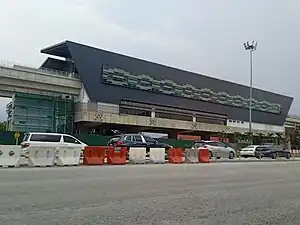
SA03 BU11 | |||||||||||
|---|---|---|---|---|---|---|---|---|---|---|---|
 | |||||||||||
| General information | |||||||||||
| Location | Tropicana, Selangor Malaysia | ||||||||||
| Owned by | Prasarana Malaysia | ||||||||||
| Operated by | Rapid Rail | ||||||||||
| Line(s) | |||||||||||
| Platforms | 2 side platforms | ||||||||||
| Tracks | 2 | ||||||||||
| Construction | |||||||||||
| Structure type | Elevated | ||||||||||
| Parking | Available | ||||||||||
| Other information | |||||||||||
| Status | Under construction | ||||||||||
| Station code | SA03 | ||||||||||
| Services | |||||||||||
| |||||||||||
The BU11 LRT station is a Light Rapid Transit (LRT) station that serve the suburb of BU11 Bandar Utama, Petaling Jaya Malaysia serves as one of the stations on the Shah Alam line. The station is located next to SPRINT Highway Damansara Toll Plaza.The station is an elevated rapid transit station in forming part of the Klang Valley Integrated Transit System.[1]
The station is marked as Station No. 3 along with the RM9 billion line project with the line's maintenance depot located in Johan Setia, Klang. The BU11 LRT station was expected to be operational in February 2024, but Transport Minister Anthony Loke mentioned that the overall line would be expected to be operational by 1st March 2025 adding more delays to the opening of the Shah Alam Line.[2] It will have facilities such as multi-story park and ride, kiosks, restrooms, elevators, taxi stand, and feeder bus among others.[3]
Surrounding Area
- BU11 residential, Bandar Utama
- The British International School of Kuala Lumpur
- First City University College
- SJK(T) Effingham
- Kuarters Institusi Pendidikan Bandar Utama
- Tropicana Landscape & Nursery
- Merchant Square Comercial Area
- Centerpoint Bandar Utama
- Bayu Puteri Apartment
- Pangsapuri Permai
- Pangsapuri Damai
- SMK Tropicana
References
- ↑ "Pelan Setiap Stesen". Prasarana Malaysia. Archived from the original on 2015-05-22. Retrieved 2015-05-17.
- ↑ "LRT3 TO START OPERATION IN MARCH 2025 - ANTHONY LOKE". BERNAMA. 2023-04-07. Retrieved 2023-07-05.
- ↑ "Jangka Masa Projek LRT3". Prasarana Malaysia. Archived from the original on 2015-05-27. Retrieved 2015-05-17.
External links
3°07′59″N 101°36′21″E / 3.1331549°N 101.6058634°E