The Baalbek Stones are six massive Roman[1] worked stone blocks in Baalbek (ancient Heliopolis), Lebanon, characterised by a megalithic gigantism unparallelled in antiquity.
The smallest three are part of a podium wall in the Roman complex of the Temple of Jupiter Baal (Heliopolitan Zeus) on Tel Baalbek and are known as the "Trilithon". Each of these is estimated at about 750–800 tonnes (830–880 short tons).
The remaining three are Roman monoliths, not part of a larger structure, conventionally known as the "Stone of the Pregnant Woman" (estimated at 1,000 t), the "Stone of the South" (est. 1,242 t), and the "Forgotten Stone" (est. 1,650 t). These are, in reverse order, the first, third, and tied fifth largest known stones ever quarried in human history. They are believed to have been intended for the nearby Jupiter Baal complex, possibly as an addition to the Trilithon; but, perhaps due to their size, they were never removed from their quarry. They have not been used since their extraction in ancient times.[2]
Numerous archaeological expeditions have gone to the site starting in the 19th century, primarily German and French groups, and research has continued into the 21st century.[3]
Stone of the Pregnant Woman

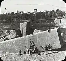
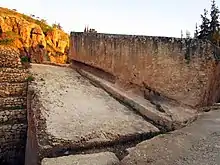
The Stone of the Pregnant Woman (Arabic: حجر الحبلي, romanized: Ḥajar el-Ḥible), also called the First Monolith, still lies in the ancient quarry at a distance of 900 m from the Heliopolis temple complex.[4] Although the smallest of the three monoliths, it is also the most famous due to its fine condition, the imposing angle at which it lies, and its never having been fully hidden by earth.
In 1996, a geodetic team of the Austrian city of Linz conducted topographical measurements at the site which aimed at establishing the exact dimensions of the two monoliths and their possible use in the construction of the gigantic Jupiter temple.[5] According to their calculations, the block weighs 1,000.12 t,[6] thus practically confirming older estimations such as that of Jean-Pierre Adam.[7]
The rectangular stone block is:
- 20.31–20.76 m long[8]
- 4 m wide at the base[8]
- 4.14–5.29 m wide at the top[8]
- 4.21–4.32 m high[8]
- Has an estimated density of 2.6–2.8 g/cm3[8]
There are multiple stories behind the name. One says the monolith is named after a pregnant woman who tricked the people of Baalbek into believing that she knew how to move the giant stone if only they would feed her until she gave birth.[9] Others say the name comes from the legends that pregnant jinn were assigned the task of cutting and moving the stone,[10] while others say that the name reflects the belief that a woman who touches the stone experiences an increase in fertility.[11]
Stone of the South

The Stone of the South (Arabic: حجر القبلي, romanized: Ḥajar el-Guble), also called the Second Monolith, was rediscovered in the same quarry in the 1990s. With its weight estimated at 1,242 t, it surpasses even the dimension of the Stone of the Pregnant Woman.[12] (There is some confusion over the naming, due to its location having been forgotten, and accordingly some sources identify "Stone of the South" as an alternate name of the Stone of the Pregnant Woman.)
These are dimensions of the rectangular stone block, assuming that its shape is consistent in its still-buried parts:
Forgotten Stone

The Forgotten Stone, also called the Third Monolith, was discovered in the same quarry in 2014 by archaeologists from the German Archaeological Institute. Its weight is estimated at around 1500 tonnes (1650 Tons), making it the largest stone ever quarried.[13]
It is 19.6 metres (64 ft) long, 6 metres (20 ft) wide, and at least 5.5 metres (18 ft) high.
Trilithon

The Trilithon (Greek: Τρίλιθον), also called the Three Stones, is a group of three horizontally lying giant stones which form part of the podium of the Temple of Jupiter Baal at Baalbek. The location of the megalithic structures is atop a hill in the region known as Tel Baalbek. Each one of these stones is 19 metres long, 4.2 metres high, and 3.6 metres thick, and weighs around 750–800 tonnes(826-881 Tons). The supporting stone layer beneath features a number of stones which weigh an estimated 350 tonnes and are 11 metres wide.[7]
Although they do not form a trilithon in the modern archaeological sense, they have been known as the Trilithon since at latest the early Byzantine period.[14]
See also
References
- ↑ Adam, Jean Pierre; Anthony Mathews (1999). Roman Building: Materials and Techniques. Routledge. p. 35. ISBN 978-0415208666.
- ↑ Ruprechtsberger 1999, pp. 7–56
- ↑ Adair, Aaron. "Moving the Stones of Baalbek–The Wonders of Roman Engineering". Fleeing Nergal, Seeking Stars. Retrieved 2016-03-02.
- ↑ Ruprechtsberger 1999, p. 10
- ↑ Ruprechtsberger 1999, pp. 9–11
- ↑ Ruprechtsberger 1999, p. 15, the calculation is based on a length of 21 m.
- 1 2 Adam 1977, p. 52: 970 t
- 1 2 3 4 5 Ruprechtsberger 1999, p. 15
- ↑ Ruprechtsberger 1999, pp. 12f.
- ↑ Hanauer, James Edward (1907). Folk-lore of the Holy Land: Moslem, Christian and Jewish. Duckworth & Company. pp. 74–. Retrieved 12 March 2013.
- ↑ Doyle, Paul (2012-03-01). Lebanon. Bradt Travel Guides. pp. 213–. ISBN 9781841623702. Retrieved 12 March 2013.
- 1 2 3 4 5 Ruprechtsberger 1999, p. 17
- ↑ "Archaeologists Discover The World's Largest Ancient Stone Block". io9. Retrieved 2014-11-29.
- ↑ Sophocles, Evangelinos Apostolides (1914). Greek Lexicon of the Roman and Byzantine Periods. Cambridge, Massachusetts: Harvard University Press. p. 1092.
Bibliography
- Adam, Jean-Pierre (1977), "À propos du trilithon de Baalbek: Le transport et la mise en oeuvre des mégalithes", Syria (in French), 54 (1/2): 31–63, doi:10.3406/syria.1977.6623
- Ruprechtsberger, Erwin M. (1999), "Vom Steinbruch zum Jupitertempel von Heliopolis/Baalbek (Libanon)" [From the quarry to the Jupiter temple of Heliopolis/Baalbek (Lebanon)], Linzer Archäologische Forschungen (in German), 30: 7–56
- Massih, Jeanine Abdul (2015). "The Megalithic Quarry of Baalbek: Sector III the Megaliths of Ḥajjar al-Ḥibla". Journal of Eastern Mediterranean Archaeology & Heritage Studies. Penn State University Press. 3 (4): 313–329. doi:10.5325/jeasmedarcherstu.3.4.0313. JSTOR 10.5325/jeasmedarcherstu.3.4.0313.
External links
 Media related to Stone of the Pregnant Woman at Wikimedia Commons